| Home | Newsletter | Locations | Diary |
|
Indexes |
|
|
|
|
|
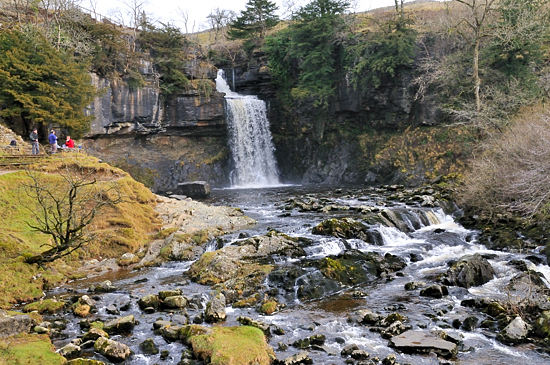
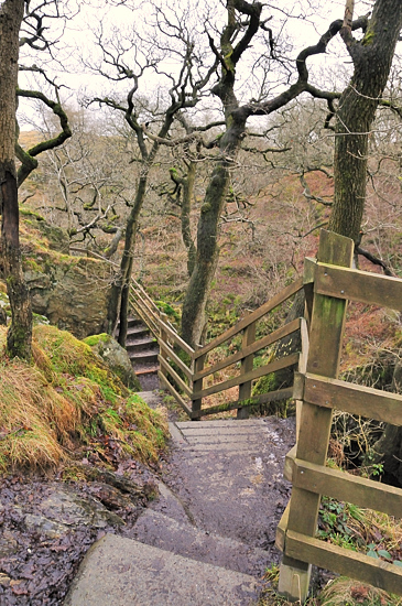
Geography and a bit of history Ingleton's postal address is Lancashire and sits on the boundary of Lancashire and North Yorkshire. The Waterfalls Trail is just in the Yorkshire Dales National Park. Ingleton sees the meeting of two rivers the River Twiss and the River Doe to form the River Greta which flows under the viaduct and beyond. Both rivers travel through densely wooded gorges on their way down and within these lies England's greatest concentration of waterfalls. Ingleton has been known for its other attractions, the caves etc since the end of the 18th Century, but the falls were hidden from view and people were not aware of their existence. Then the Lancaster Guardian, amongst others, ran articles on the scenery and surrounding area and this generated a lot of public interest. So much so that an 'Improvement Company' was formed and pathways and wooden bridges were built to allow better access and it has remained a tourist attraction since Good Friday, 11th April 1885 when it first opened to the public. The Waterfall Trail The Ingleton Waterfalls Trail is a circular 4.5 mile walk which takes you from the centre of Ingleton up the side of the River Twiss across the hills and back to Ingelton alongside the River Doe. It is owned and managed by the Ingleton Scenery Company who provide a car park within Ingleton at the start of the walk, also in the Car Park area are toilets and a cafe. You will need 2.5 to 4 hours to complete the full route and the trail follows a well-defined footpath over inclined ground, where a climb is necessary steps are provided. In total the number of steps provided at different points over the whole of the trail is 1,000. It is open 7 days a week from 9am until dusk, and our winter visit in January 2009 the gates to the car park were closed at around 2pm. It is not a route for the infirm, featuring a number of steep, narrow and rocky sections, as well as protruding tree routes and uneven ground. The trail takes you through ancient oak woodland and impressive scenery and along the way you get to see some spectacular waterfalls and geological features. The woodlands contain oak, ash, hazel and wych elm trees as well as yew trees on the cliffs and scars. Ground flora include dogs mercury, wild garlic, tufted hair grass, great wood-rush and bilberry, there is also a lot of woodland mosses, such as Yorkshire feather moss, liverworts and an enclosure with reintroduced lady's slipper orchid. Around the waterfalls you may see, at certain times of the year, a variety of birds, Brown Trout leaping and dippers may be seen at water level, and probably other wildlife besides. You need to be prepared for this walk, make sure you are wearing suitable footwear, such as walking boots, Wellington boots or substantial shoes, have clothing suitable for weather changes and plenty of water to drink. A hiking pole or substantial monopod would also help in getting over some parts. Many visitors also take small packed lunches to eat on the way round, there are a number of resting areas. It's usual to tackle the route clockwise, walking north along the Twiss and then south along the Doe. Being a circular walk you could walk it from either end, but the majority of visitors start at the Broadwood Car Park. Starting from the car park you start the walk alongside the River Twiss, which has Swilla Glen, Thornton Glen, Pecca Falls, Holybush Spout and Thornton Force. Then following the path across fields and hills you reach the valley of the River Doe which has Beezley Falls, Rival Falls, Baxenghyll Gorge, Snow Falls, and Twistleton Glen. In all 8 waterfalls or groups of waterfalls. Each one an impressive sight and each one different in character, size and spectacle. Although usual to tackle the route clockwise from the car park, walking north along the Twiss and then south along the Doe. You could do the River Doe part of the walk first, as you can enter from the village and work your way backwards, paying at the end or after reaching Beezley Falls, turn around and walk back the same way you came. But you would have to try to remember afterwards to go to the normal entry point so as to pay the entrance fee. The backward way around may also be an option you would like to take so as to make an earlier start in the summer months before the car park and normal entrance is open. If you wanted to get to a particular waterfall you might find it quicker to get to it from the small Chapel le Dale road that is crossed when you cross from one valley to the other. We did our Waterfall Trail in January 2009 and although the trees were bare, it was winter, it was a nice fine day and not too cold. It would be good at some point to also do it in the summer, and again with autumn colours. In addition to this location guide for the walk we have location guides for the major waterfalls on it, and in this guide you will find links of to these guides and they each have the option to return you to the place in this guide that you left, so that you can continue your journey. This location guide takes the normal clockwise route. In addition to the images in this guide and on location pages for waterfalls we have 2 Galleries, one for each of the valleys. You will also find Ordnance Survey grid references and links that throw up in a new window, Multimap pages showing a labelled Ordnance Survey map. The Walk in Detail
Grid Reference
SD692733 Streetmap
We started our walk from the Broadwood Car Park and the route initially runs along the west bank of the River Twiss through woodland, over pathways and steps with many vantage points of cascades and mini falls along the way. This is the first time that we noticed that the water not only makes a gushing noise when moving over the rock bed, but there is also a deep bass sound, just like that of a bass drum rhythmically beating below. If it's quiet and not too many people about take time to pause and listen. Amongst the peacefulness of this setting there is definitely a drummer somewhere ? From here you walk into Swilla Glen. Swilla Glen
Grid Reference:
SD693735
Streetmap
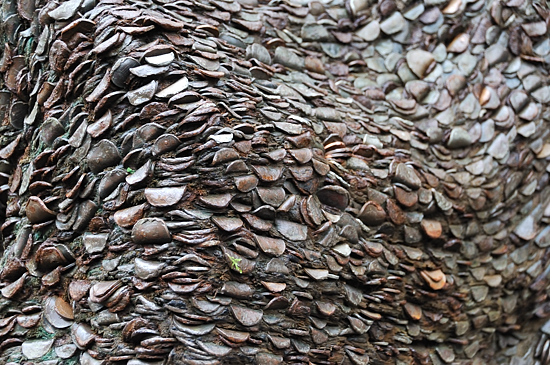
The tree lined Swilla Glen is a rocky dell cut deep into the limestone. Trees here include oak, ash, birch and hazel. There are a variety of ground plants such as bluebells and dogs mercury. During our visit the most prominent colour was green, not from the leaves on the trees - there weren't any, but amongst the fallen brown leaf matter, protruding on tree bark, rocks and just about anything it could grab hold of were mosses and ferns, which thrive in the moist conditions of the gorge. There were many opportunities to get down into low enough positions along the riverbank to get pictures of the water rolling over the rocky river bed. It was here that we also saw the first Money Tree!, an old fallen tree which had been embedded with real money, there were two in this Glen.
Walking on through Swilla Glen the path crosses to the east bank over Manor Bridge the first of a number of bridges on this walk, in to Thornton Glen. Thornton Glen
Grid Reference:
SD695750 Streetmap
Is situated on the east bank of the River Twiss, 1.75km from the car park and ends at Pecca Bridge. It is a site of Ancient Semi-Woodland and a Site of Scientific Interest because of its geology and associated flora. The tree species are dominated by Oak and Ash with willows and alder along the riverside and the under storey has holly, thorn, hazel and rowan. It is owned and managed by the
Woodland Trust.
Grid Reference
SD695748
StreetMap
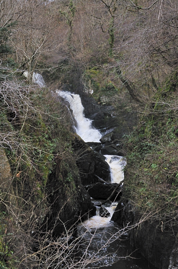
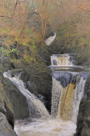
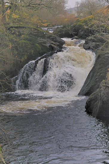
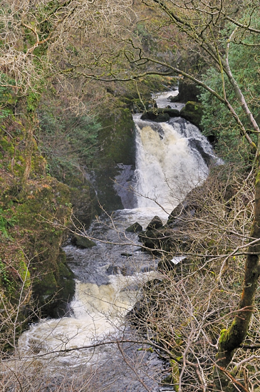
This first set has 5 main waterfalls in a series, dropping a total of 100ft (30 metres). Most of them are provided with wooden observation platforms, but not all of them are easy to see. Following the steps and pathway, seeing some of the falls here from above, you then reach the Pecca Twin Falls. Pecca Twin Falls This set of falls are not as high as some of the others, but there are two falls one higher than the other dropping down into one plunge pool below. There is a viewing platform to get a good view and as the steps wind away and up higher you can take a look back and get some aerial effect shots of this part of the Pecca Twin Falls. You now have a bit of a climb, following the path along steep wooden walkways and rocky terraces, the next clearing you come across shows Hollybush Spout. Grid reference
SD694750
StreetMap
Moving from one river valley to the other
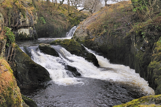
Since 2010 also at this point is the Falls Refreshment Centre, (seasonal open times ask at ticket office on your visit) where you can take a rest and take on some light refreshments before continuing on your journey around the trail. As we leave the farm, we could if we had wished taken a short diversion to see a ford and stepping stones that crosses the River Doe a little way above the falls, these are not visible from the path near the falls. A number of other footpaths cross the river north of here and three further sets of stepping stones are shown on some Ordnance Survey maps, all a short distance from the B6255. Going down the steps there are a couple of viewing areas and on the right wooden seats which overlook the first set of falls on this River, Beezley Falls.
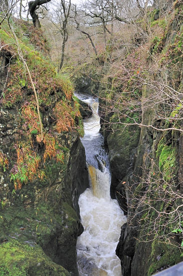
At this point the river has carved a deep narrow gorge into the rock, believed to be 60ft down. There are a number of twists and turns and plenty of opportunities to overlook the spectacular sight both below and around you. There are several falls within this section as the river plunges down through, but they do not appear to have names. At one point there is a viewing platform across the gorge, giving a good view of the river down below. Eventually the gorge opens out into the first of a number of rocky areas. There is a steep set of steps down to this area, the wooden path is surrounded by mini waterfalls coming off the hillside around, the river runs on through and some people picnic on the limestone rock bed amongst the small rock pools of water, and you can, if it's not covered in water, and you can figure out how to get down there.
may see some wild garlic and typical moorland/heathland species such as bracken and fern. The only access to this woodland is via the paths provided for the Waterfalls Trail, from where the final footbridge takes you across the River Doe into another wide rocky dell, where again some stop to take a picnic. Smaller waterfalls continue through this area and particularly from the last ridge you get to see some close up. Inside the south west boundary of the Woodland Trust boundary there are still the remains of small scale slate quarrying and you go past a sign which warns that some blasting can take place between 9am and 5pm. Just past here you pass through a gate onto another solid path. The river continues to meander on through the valley towards Ingleton Village. The footpath you are on is now solid. Once out of the Glen you go through a very
narrow gate, by a stream making its way down to the river, into an open area
above Ingleton. Initially you have to walk up a little, sheep may be
grazing on the hillside and then it's downhill from here. The walkway then widens
out and on the opposite side of the river is the remains of an old quarry which
nature has reclaimed and in front of you the remains of the old lime kilns and
workshops. Beyond here the Waterfall Trail footpath, at Grid Reference
SD698734
Streetmap,
There are signs from here showing the way back to the Waterfall Trail Car Park, which goes past a YMCA building, through a children's park area, past an outdoor swimming pool, originally built by local miners in 1933 and onto a tarmac path along the river. A head of you, you can see a road bridge and behind this, a lot higher up, a railway viaduct. The path takes you through a row of pretty little cottages and up onto the road bridge over the River Doe, where the road then meanders back, over another bridge over the River Twiss, and towards the entrance of the Car Park on your right. If you decide not to follow the signs back to the car park initially, then you can take a walk around Ingleton village, which has a lot of small interesting shops, cafes and other places for refreshments. The Viaduct The 11 arch Viaduct is the most noticeable feature of the area, as you go by, standing high in the air across the valley. This was constructed to join two stations operated by different railway companies and opening up a cross country route. It is 800 feet long and 80 feet high, crossing both the Rivers Doe and Twiss, just before they join to form the River Greta. There are a number of other viaducts in the area, some in use and others like this, now monuments to past activities. Parts of a smaller, lower one runs through the car park for the walk. The Falls Cafe and Gift Shop At the end of your walk, when you get back to the Car Park you could browse around the Gift shop, or take some refreshment in the Cafe. The cafe provides light refreshments of sandwiches, baked potatoes, ice cream, drinks and cakes. The Reverse Route If you decide to take the walk the other way round, from the main village car parks, then from Main Street, go into The Square and then down to the end of Thacking Lane where you will find the gate which gets you onto the Trail.
.
Please let us know any other information that we can add to the Further information and Planning Grids or page and any errors that you discover. Before making a long trip to any location it is always wise to double check the current information, websites like magazines may be correct at the time the information is written, but things change and it is of course impossible to double check all entries on a regular basis. If you have any good photographs that you feel would improve the illustration of this page then please let us have copies. In referring to this page it is helpful if you quote both the Page Ref and Topic or Section references from the Grid below. To print the planning grid select it then right click and print the selected area. Please submit information on locations you discover so that this system continues to grow.
|
|||||||||||||||||||||||||||||||||||||||||||||||||||||||||||||||||||||||||||||||||||||||||||||||||||||||||||||||||||||||||||||
|
|||||||||||||||||||||||||||||||||||||||||||||||||||||||||||||||||||||||||||||||||||||||||||||||||||||||||||||||||||||||||||||
.
|
|||||||||||||||||||||||||||||||||||||||||||||||||||||||||||||||||||||||||||||||||||||||||||||||||||||||||||||||||||||||||||||
|
|