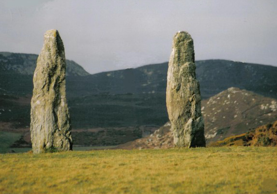
Penrhos Feilw Standing
Stones
Holyhead, Anglesey
|

Location Guide |

 Photo by
Ray West Photo by
Ray West

These standing stones, accessible
by a path from the road, were erected about 2000 years BC. They are of local
schist and are each 3m high. They are set about 3.5m apart. Another account puts
them a little later as bronze age.
There is a local story that they
were the centre two stones of a stone circle and formed a stone cist containing
bones, arrowheads, and spearheads.
|
Location: Penrhos Feilw Standing Stones,
Holyhead, Anglesey |
|
Grid Reference: SH227809 |
Ceremonial County:
Anglesey
 |
|
Map Link:
Get-A-Map  Multimap

|
Aerial photo: |
|
Getting there: From the A55 take the exit for
the B4545 to Trearddur, at the fork junction take the right fork down the
minor road. Follow this to the T junction and turn right. Take the next
right and the stones are along on the left. |
|
Access: In a field signposted from the road |
Website:
CADW
 |
Other Useful Websites:
Geograph
 No Wikipedia page
 |
|
Email: |
|
Address: |
|
Postcode: |
Telephone: |
|
Opening Times: open all the time |
|
Charges: Free |
Nearby Locations:
South Stack 

 South Stack
Lighthouse

 |
|
Other Location Pages: |
Other Relevant Pages:
Anglesey Attractions
 Anglesey
Attractions Map
 |
|
Notes:
|
|

|
Please let us know any other information that we
can add to the Grid(s) or page and any errors that you discover. Before making a long trip to any location it is always
wise to double check the current information, websites like magazines may be
correct at the time the information is written, but things change and it is of
course impossible to double check all entries on a regular basis. If you have
any good photographs that you feel would improve the illustration of this page
then please let us have copies. In referring to this page it is helpful if you
quote both the Page Ref and Topic or Section references from the Grid below. To print the
planning grid select it then right click and print the selected area.
Please submit information on locations you discover so
that this system continues to grow.
|