| Home | Newsletter | Locations | Diary |
| Indexes |
|
| Travellers Resource |
|
|
|
|
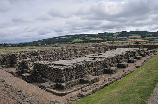
Across the site looking over the two granaries Corbridge started as a series of forts at the intersection of two major roman
roads, Stanegate
After other forts were constructed as a part of
Hadrian's Wall,
Today as you visit the Corbridge site you see remains from several time periods, so as you walk along the main street of this Roman garrison town you can see where there were granaries, a fountain house, barracks, workshops, temples, houses, several headquarter buildings, at least one with a below ground strong room and more. A lot of the finds discovered on the site are in its museum. The remains under the surface cover a far greater area than the site that is now open. Prior to the Romans, there were Iron age round houses on this site, and the
first Roman fort was half a mile to the west in about 79AD, known now as Red
House Fort, and was principally a supply camp for campaigns. I have suggested
before in relation to stone circles and
Roman Roads
The first fort on this site was constructed of turf with a timber inside, this is thought to have been built around 84AD. The central area of this was a headquarters building, barracks to the north and south and there were a pair of granaries, workshops, accommodation for admin staff and the commanding officers house. This is thought to have housed a 500 strong cavalry unit called Ala Petriana. This fort burnt down in around 105AD. A second fort was built to replace this and was very similar to the first, again with internal buildings made of timber. This lasted to about 120AD.
The third fort on this site at Corbridge, again similar in design was constructed to house troops for the new Hadrian's wall. This was built as an infantry garrison. The policy changed and more forts were built on the line of the wall, making this surplus to need at that time. Around 139AD it was decided to build a new wall
across, higher up, and the
Antonine Wall
In around 163AD the
Antonine Wall
The area around the fort had, like many forts, developed into a civilian area, and in the case of Corbridge this appears to have gone on developing after the fort was no longer required, and developed further to become a garrison town. It had a small legionary dept in the centre and over time different parts of the fort were redeveloped. Timber buildings were erected over a section of the filled in ramparts and metal working furnaces built over the east and west ramparts. At about the same time a number of small rectangular stone buildings, some think temples, were constructed to the south of the main street. No one really knows what these were used for at this point, it may be they were part of the supply side, hotel like rooms, or even an early red light district.
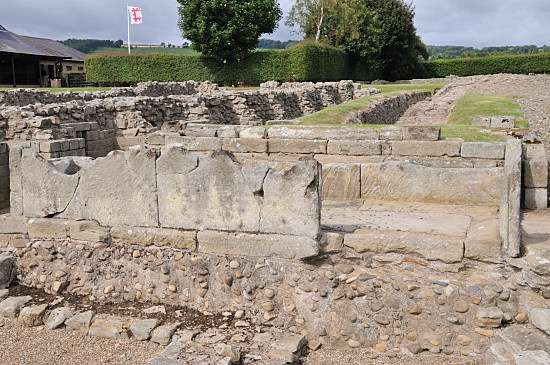
Shortly before 180AD, to the north of the main road, major redevelopment occurred with two granaries, a fountain house and the large site known as site 11, that may have been a market, a larger administrative centre, training centre or storage and supply complex. The fountain and water supply for this, probably suggests more than just a supply base and favours the idea that this was intended to form the basis of a new regional town or city centre or had some other specialist use we have still to discover. Around 180AD, an uprising and the wall being crossed with many military people killed, brought construction to a halt. A ruthless general called Ulpius Marcellus, was appointed and brought the situation under control. A lot of burnt out timber is found representing this time, although its not known if the native tribes burnt the buildings, the Romans destroyed them before retreating to destroy food and other stocks left behind, or it was done for some other reason. Later the granaries and fountain house was completed but the unknown building we call site 11 was perhaps not.
Stone trough that was in front of the fountain house Behind the building on the south of the main
street, two compounds were built, coming off a side street, these compounds had
thick walls, and its thought had a military use, remains suggest they were used by the second and
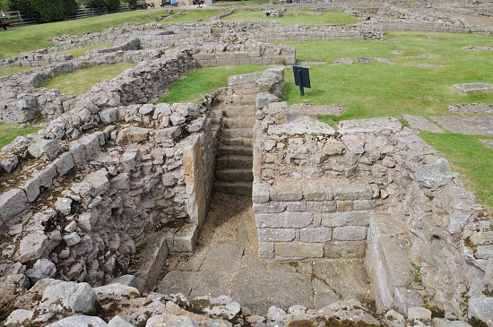
sixth legions. The eastern compound had at least two residential houses, plus
either workshops or barracks, and a headquarters building with sunken vault
under, while the western one may have had workshops or
perhaps barracks. People have come up with various possible interpretations for
their use. I have read elsewhere that the stonework for
Hadrian's Wall
Over the third and fourth centuries the town
developed, the two compounds were joined together, and the town took on a grid
structure with housing covering at least 27 acres (11hectars) most outside the
area open to see now. An older guide book from the the 1960's says 35-40 acres.
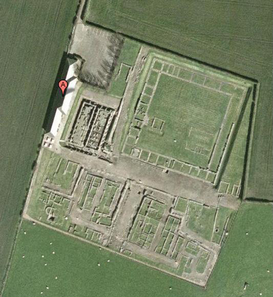
If you look at the
Google
The town developed also along the Stanegate and Deer street. The newer houses included some of wealthier people with two floors, and developments included potters, leather workers, and smiths. In part the driving force for this would have been servicing the forts and troops at the wall, part in developing natural resources nearby like lead, Iron and coal and part through its position on the main route to the north. The towns main street was resurfaced the last time in the middle of the fourth century and coins found suggests the town was active until at least the end of the fourth century. In 306AD there were some reorganisation of the frontiers, and in 407AD the British based forces chose their own Emperor, who rather than being delighted with his realm, set off to the continent with a large part of the army never to be seen again. Britain became cut off from the rest of the empire and from this point Roman control in Britain collapsed. We don't know much more of Corbridge as a roman town after this time.
A headquarters or Administrative building with underground vault from the period of the town In 1201 in the reign of King John, some digging took place at Corbridge, looking for treasure, but nothing was found that interested them. In the 16th century there were said to be a lot of remains but by the 18th the area was nearly all levelled and under the plough. The local Corbridge parish church and many other buildings in the modern Corbridge to the east making good use of the available stone. During the 19th century some parts were discovered either as a result of agricultural improvements or small scale excavations but it was not until systematic excavations occurred from 1906-1913 that the plan of the town was discovered. In 1933 the central part of the site and major buildings were discovered and excavated. From 1934 to 1973 except for the war years, excavations took place for a part of the year, with other excavations in 1973 and 1976. The section under where the museum building now stands was explored in 1980. During this process several coin hordes have
been found, mostly near the fountain house, and in 1964 a chest was discovered
in the South east corner of site 11, near the road and away from the fountain
house, a wide range of items were found that are now in its own museum and the
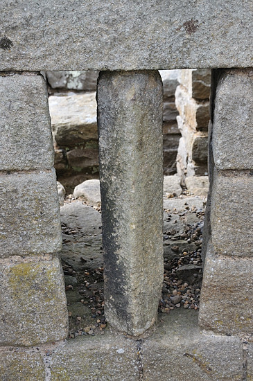
Great North Museum Early archaeology was done with a trowel in one hand and a bible in the other, and we so often see plans with loads of ceremonial use or in this case large numbers of temples. Its always wise to take a new look at these ideas. We also find here what appears to be, and we are told are granaries, but with large pillar bases at the front that might suggest grander use, and positioned right next to the aqueduct and fountain house. The granaries having an elaborate floor and ventilation system to keep the grain dry hardly seems good planning, so perhaps they used the same technology and design but had another use. The largest part of the site is the unknown building known as site 11, with its large open centre, adds to the confusion. In addition the two compounds and vast number of workshops and variety of trades, is unusual. This leaves you with the opportunity to dream up your own explanation of how this settlement may have looked and what went on here. Could you for example imagine that as well as a supply and repair base for the forts along the wall, this was also a form of college, training new skills and developing new craftsmen to feed the wall and other roman forts and towns. Perhaps recruits went through here before going to the wall or had periods of release from their normal duties to develop trades. Its location is ideal with a direct road to the northern capital at York and on the route to very many of the northern forts.
Today we see a site where the development over the years can be seen, for example the street level is well above the base of the pillars, so you have to climb out of the remains north of the road onto the road. We also see the range of buildings and elaborate drainage and water systems. The most noticeable feature as you enter is the remains of the two large granaries with much of the floor supported by pillars still in place and how the ventilation system worked can be seen. From here looking along the edge of the roadway you see the road height and to the left of this the lower ground level and base of the pillars. It's suggested that these pillars supported a large canopy to keep weather out of the granaries when open. Next to this is the remains of the fountain house and the tank that the water was fed into. As you walk around the southern part of the site there is some undulations caused by land settlement over older developments below. A guide book is available and if you have the chance, get this in advance so that you can read what it has to say about the various features and its interpretation of events. This is now an English Heritage attraction, you will find you can get guide books for a range of the attractions in this area at any of the other English Heritage shops, so if visiting the wall area over several days you can read ahead. You can also order guide books by post. See more photographs in the
.
Please let us know any other information that we can add to the Further information and Planning Grids or page and any errors that you discover. Before making a long trip to any location it is always wise to double check the current information, websites like magazines may be correct at the time the information is written, but things change and it is of course impossible to double check all entries on a regular basis. If you have any good photographs that you feel would improve the illustration of this page then please let us have copies. In referring to this page it is helpful if you quote both the Page Ref and Topic or Section references from the Grid below. To print the planning grid select it then right click and print the selected area. Please submit information on locations you discover so that this system continues to grow.
|
||||||||||||||||||||||||||||||||||||||||||||||||||||||||||||||||||||||||||||
. |
||||||||||||||||||||||||||||||||||||||||||||||||||||||||||||||||||||||||||||
|
||||||||||||||||||||||||||||||||||||||||||||||||||||||||||||||||||||||||||||
|
|