Wroxeter Roman City
Wroxeter, Shropshire |

Featured Location Guide |
|
|

An English Heritage Site
|
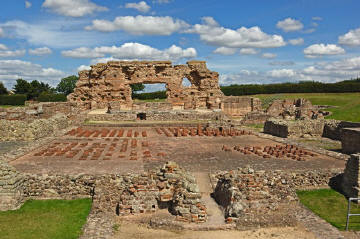
Wroxeter Roman city is the largest excavated Roman British city to have
escaped development. It was originally home to 6,000 people. The 2nd century
municipal baths and huge dividing wall are an impressive sight. As you walk the
site with a very detailed audio tour you can feel the ruins come back to life.
There is also a museum on site for the finds from various excavations.
A Little bit of History
|
Wroxeter Roman
city (Viriconium
or Uriconium) was at one time the fourth largest city in Britain,
surpassed only by London, Cirencester, and St Albans. It stood at the frontier
of Roman Britain and Wales. It was the capital of the British tribe known as the
Cornovii, and is the largest ancient city in Britain to have survived modern development
unscathed, probably due to the fact that it's medieval successor, Shrewsbury was
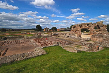
built on a site nearby. The ancient city ramparts enclosed a huge area of 78 hectares, now mostly gently rolling pasture fields, but nearly 2000 years ago
would have been a bustling city packed with houses, shops, temples and other buildings laid out within a regular street grid.
Only a very small part of the city has been exposed by excavation, and only the Roman Baths are now on display to the public. |
  |
It has always been a Roman foundation and was first
settled by the Roman Army in AD48. It is on the line of the Roman road known as
Watling Street. In it's early years it probably would have been a 'temporary
marching camp', but when Emperor Nero decided to invade Wales in AD58 the
fortress would have become permanent.
It is thought that the 14th Legion occupied the site
from AD58-AD69 and then from AD69-AD80 the 20th Legion took residence. Once it's
military use came to an end it would have been handed over to the civil
authorities and become a settlement for retired veterans. This tribal centre
would be given it's own administration and a degree of local autonomy. These
sites would be distinguished by the layout of their streets. There was also a
law court, market and large public baths.
Under the rule of Emperor Hadrian in the early 2nd
century it was to become a more substantial city when a new civic centre was
built with a bath house, Basilica and other buildings and colonnades. During the
2nd century it continued to be expanded with a new defensive ditch and bank dug.
Over time through unstable political environments and increased maintenance
costs many of the buildings became derelict and during the 4th century those
buildings that became unsafe were dismantled, while others had a change of use.
The bath house for example was used for grain storage for some time.
Once the Romans left, the city received a reversal in
fortunes, the Basilica was cleared of the small buildings and a new building
with two wings and a long western annex was built, and numerous other buildings
were built along the streets together with several barns. It is not known when
the city was finally abandoned but it is believed to have been somewhere between
AD500 and AD650.
  |
  |
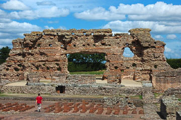
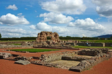
| 'The Old Work' one of the largest pieces of
freestanding masonry left from Roman Britain. Once part of the original
south wall of the baths basilica. |
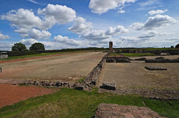
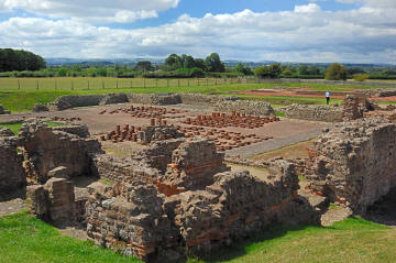
The large hall, with the largest remaining roman wall at the very
bottom. This hall would have been used for social activities and sports. |
  |
  |
| The remains of the hypocaust, under floor
heating for the baths' hot rooms. |
Some more the grounds/ruins that can be seen. |
Click on the images to see the bigger picture
Planning Grid
|
Location: |
Wroxeter
Roman City, Shropshire |
|
Grid Reference: |
SJ565087 |
|
Getting there: |
Located at
Wroxeter 5 miles E of Shrewsbury on B4380 |
|
Access: |
Easy access
from car park, into and through shop/museum |
|
Parking: |
It has it's
own free car park. |
|
Facilities: |
Toilets. Audio Tour. |
|
Things To Do,
See and Photograph: |
Extensive
ruins which can be photographed from many angles, the most photographed part
is probably the North Wall of the frigidarium. Lots of open countryside
around and vast skies. |
|
What to take: |
Camera,
Tripod, Grads |
|
Nature highlights: |
|
|
Address: |
Shropshire |
|
Postcode: |
SY5 6PH |
|
Telephone: |
01743 761330 |
|
Opening times: |
1 Mar-31 Oct daily 10am to 5pm
1 Nov-28 Feb Wed-Sun 10am to 4pm
Closed 24-26 Dec and 1 Jan |
|
Charges: |
English
Heritage Members - Free; Non-Members Adults £4.40; Child £2.20; Family £11; Concession
£3.70 |
|
Photo Restrictions: |
No commercial
photography is allowed in all their grounds, it is not permitted in some
buildings for conservation purposes, usually a no photography symbol is
present on entry to the building where this restriction is in place. |
|
Other Restrictions: |
|
|
Special Needs Access: |
Disabled access |
|
Special Needs Facilities: |
|
|
Children Facilities: |
|
|
Dogs Allowed: |
|
|

|
Please let us know any other information that we
can add to the Further information and Planning Grids or page and any errors that you discover. Before making a long trip to any location it is always
wise to double check the current information, websites like magazines may be
correct at the time the information is written, but things change and it is of
course impossible to double check all entries on a regular basis. If you have
any good photographs that you feel would improve the illustration of this page
then please let us have copies. In referring to this page it is helpful if you
quote both the Page Ref and Topic or Section references from the Grid below. To print the
planning grid select it then right click and print the selected area.
Please submit information on locations you discover so
that this system continues to grow.
|