|
Location: Quay Street Green, Minehead,
Somerset |
|
Grid Reference: SS971467 |
Ceremonial County:
Somerset
 |
Map Link:
StreetMap
 |
Aerial photo:
Google Aerial Photo
|
|
Getting there: From the M5 take J25, follow
A38 into Taunton and the the A358 to Williton and then turn left onto the
A39 to Minehead. |
|
Website:
www.mineheadsomerset.co.uk
|
|
Other useful
websites: |
|
Notes: A seaside resort but also one end of
the West Somerset Railway (steam railway), which starts at Bishops Lydeard. |
Exmoor National Park
-
Exmoor National Park
Straddles the two counties of
Somerset and Devon, total area of the park covering 267 square miles of hilly
open moorland which includes 34 miles of coast, the piece of the park that you
will go through on this path.
Clovelly
Set into a steep hillside, it is probably one of the most famous villages in
England. It has a single cobbled high street which winds its way down to the sea
at the bottom. No vehicles are allowed in the High Street and during the summer
months you will find both people and donkey's transport goods to the shops,
hotels and other local businesses. There is visitor parking at the top adjacent
to the visitor centre and you walk on foot down the high street with 16th
century cottages on either side to the small harbour. There is plenty to see and
do.
|
Location: Clovelly, near Bideford,
Devon |
|
Grid Reference:
SS315247 |
Ceremonial County:
Devon
|
|
Map Link:
StreetMap
|
Aerial photo:
Google Aerial Map
|
|
Getting there: M5 J27, take the A39 to
Higher Clovelly and then the B3237 to the Clovelly Visitor Centre before
walking down the cobbled street to Clovelly harbour. |
|
Website:
www.clovelly.co.uk
|
|
Other useful
websites: |
|
Notes: The High Street is steep and can be
slippery. It is not suitable for wheelchairs and there is no access for
vehicles. You have to walk. |
|
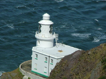
Hartland Point
Three miles of the walk goes from
Hartland Point to Hartland Quay. There are coves, cliff formations, undulating
landscape which in places is quite steep, and in places ruins. On a clear day
out to see you should be able to see Lundy Island in the distance. Here there is also
Hartland Point lighthouse,
 on the furthest outcrop, but you can get good views
from the headland.. on the furthest outcrop, but you can get good views
from the headland..
Hartland Point Lighthouse
 Nicholas Mutton
|
 |
Boscastle Harbour
A medieval harbour and village
hidden in a steep sided valley. Of course made
famous with the BBC series following the life and times of a local parish and a
little while back when they had some devastating floods, which they have now
recovered from and the tourists are back.
Tintagel Castle
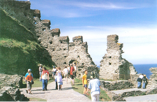

|
Location: Tintagel, Cornwall |
|
Grid Reference:
SX049890 |
Ceremonial County:
Cornwall
|
|
Map Link:
StreetMap
|
Aerial photo:
Google Aerial Photo
|
|
Getting there: From A39 at Camelford take the
B3266 towards Boscastle, after 2 miles take the B3314 to Delabole and at
fork take right on B3263 to Tintagel. |
|
Notes: See our
featured
location
 page on this page on this |
Land’s End and the Lizard
The most westerly point of mainland England. As well as the tourist
attraction situated at the end of Cornwall, there is also the stunning sea views
across to the Isle of Scilly, the
Longships Lighthouse
and
Wolf Rock
as well as
wildlife to catch up on. The RSPB have a Wildlife Discovery Centre on the cliff
top where using powerful telescopes and binoculars you can see sea birds, owls,
grey seals, basking sharks, dolphins and more.
The Cornish national bird, the Choughs had been extinct in Cornwall for 50
years until 2001 when a small number of them appeared on the coast of the
Lizard. They are now breeding successfully and can be often seen on the
peninsulas.
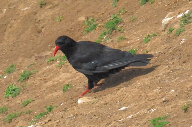
A Chough - The Cornish National Bird, can be seen on the Lizard
The Minack Theatre - an outdoor theatre in a Roman
Amphitheatre style
overlooking the harbour. Theatre productions still take place today, mainly
evening performances, but also some matinees on Wednesday's and Fridays
|
Location: The Minack Theatre, Porthcurno,
Cornwall |
|
Grid Reference: SW387220 |
Ceremonial County:
Cornwall
|
|
Map Link:
StreetMap
|
Aerial photo:
Google Aerial Photo
|
|
Getting there: From Porthcurno go up the
winding hill and the theatre entrance is on the left. |
|
Website:
www.minack.com
|
|
Other useful
websites:
|
|
Notes: Open daily all year from 10am-5pm. Last
entry in winter is 3.30pm (closing at 4pm) |
|
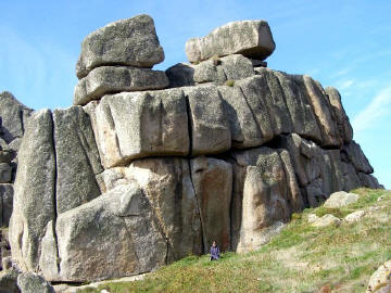
Logan Rock (a rocking tor)
An 80 ton granite boulder perched on the edge of the cliffs on a rocky
headland one mile south of Treen. The rock is finely balanced due to weathering
and overlooks Cripps Cove beneath.
It's the one on the right
which rocks
Jim Champion
|
 |
Harbour town of Fowey
With its ruins of St
Catherine's Castle, and Readymoney Cove supplying it's
local beach.
|
Location: Fowey, Cornwall |
|
Grid Reference:
SX122515 |
Ceremonial County:
Cornwall
|
|
Map Link:
StreetMap
|
Aerial photo:
Google Aerial Photo
|
|
Getting there: From A38 at Dobwalls take the
A390 to St Austell. At Lostwithiel turn onto the B3269, after about 6 miles
you reach Fowey. |
|
Website:
www.fowey.co.uk
|
|
Other useful
websites:
Wikipedia
|
|
Notes: It has ferries across the river to
Polruan (foot) and Bodinnick (vehicle). |
The
World Heritage
 Coast in Dorset stretches 95 miles and includes the
Jurassic Coastline at Lyme Regis (see grid) and
Charmouth
where you
can see fossils in the cliff faces and under foot. Coast in Dorset stretches 95 miles and includes the
Jurassic Coastline at Lyme Regis (see grid) and
Charmouth
where you
can see fossils in the cliff faces and under foot.
Chesil Beach Shingle Ridge
(aka Chesil Bank)
A well known 18 mile
shingle beach stretching from Portland to West Bay. It is separated
from the mainland by an area of salen water called Fleet Lagoon. There is also
the Fleet Nature Reserve, and a visitor centre at the Southern End of Fleet
Lagoon between Weymouth and Portland.
|
Location: Chesil Beach, Dorset |
|
Grid Reference: SY634784 |
Ceremonial County:
Dorset
|
|
Map Link:
StreetMap
|
Aerial photo:
Google Aerial Map
|
|
Getting there: From Weymouth follow the A354
to Portland, as you approach Portland the Chesil Beach visitor centre and
car park are on your right. |
|
Website:
www.chesilbeach.org
|
|
Other useful
websites:
Wikipedia
/www.jurassiccoast.com
|
|
Notes: The seaward slope is closed every year
from 1st April to 31st August to protect nesting birds. |
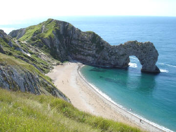
Durdle Door
| Durdle Door is a natural
limestone arch on the Jurrasic Coast near Lulworth, between Swanage and
Weymouth. Probably the most photographed and painted landmark on the Dorset
coast. A walk down to the beach is very steep, or walk around the contour of the
hill towards Scratchy Bottom and view it from the high ridge.
Michael Robinson
|
 |
|
Location: Durdle Door, Lulworth, Dorset |
|
Grid Reference: SY804803 |
Ceremonial County:
Dorset
|
|
Map Link:
StreetMap
|
Aerial photo:
Google Aerial Map
|
|
Getting there: from the A352 take the B3071 to
Lulworth Cove at West Lulworth take the road to Daggers Gate follow the
signs to the Car Park and then follow the footpath. |
|
Website:
Durdle Door
|
|
Other useful
websites:
Wikipedia
www.jurassiccoast.com
|
|
Notes: |
Lulworth Cove
Lulworth Cove is a
natural horse-shoe shaped harbour, has a pebble beach and is very sheltered.
Lulworth has it's very own butterfly the 'Lulworth Skipper'.
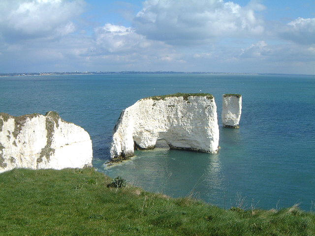
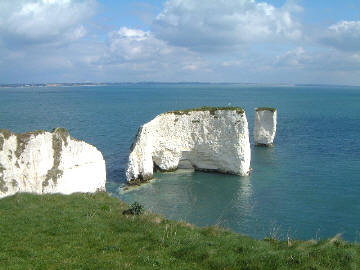
Old Harry Rock
Stacks
| Chalk stacks located east
of Studland, below the cliffs at Ballard Down. The cliff is chalk with bands of
flint and have been reduced over centuries by the sea.
The downland habitat is
home to a variety of chalk flora which is complimented by many species of
butterfly including Chalkhill Blue and Adonis Blue.
Old Harry Rocks
John Tomlinson
|
 |
|
Location: Old Harry Stacks, nr Studland,
Dorset |
|
Grid Reference: SZ055825 |
Ceremonial County:
Dorset
|
|
Map Link:
StreetMap
|
Aerial photo:
Google Aerial Photo
|
|
Getting there: Take the A351 to Swanage, at
Corfe take the B3351 to Studland and follow the footpath out to Old Harry. |
|
Website:
www.jurassiccoast.com
|
|
Other useful
websites:
Wikipedia
|
|
Notes: There are a number of car parks within
Studland and the Studland Bay area. |
Poole Harbour
Poole Harbour and quay is 3 miles of golden sands.
A large natural harbour, at it's entrance is Sandbanks where it's chain
ferry takes passengers across to the Isle of Purbeck and in it's centre is
Brownsea Island,
a haven
for the British
Red Squirrel.
It is also a gateway to the Solent with ferries
leaving for the Channel Islands and France.
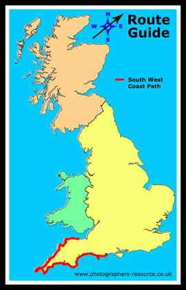
Poole Harbour is the final point on the South West
Coast Path going in this direction. There are many highlights beyond those
listed here, this is just a selection. All along the route there will also be
many more lighthouses than the ones we have mentioned here, take a look at our
Lighthouse Map of England and Wales

 within the
Lighthouses
section to pinpoint others you can see. You may also glimpse some of the
many
Islands
that lie off our coast as well. I hope you enjoyed this journey and it inspires
you to get out and have a walk of at least part of it.
within the
Lighthouses
section to pinpoint others you can see. You may also glimpse some of the
many
Islands
that lie off our coast as well. I hope you enjoyed this journey and it inspires
you to get out and have a walk of at least part of it. |
|