Swallow Falls
Betws-Y-Coed, Caernarfonshire
|

Location Guide |
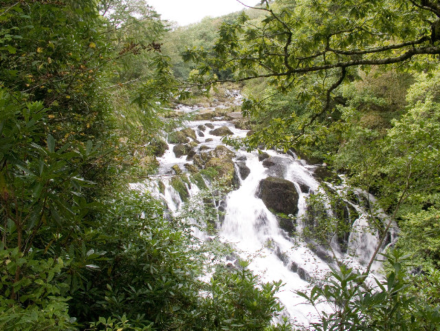
Swallow Falls (Rhaeadr Ewynnol) has many visitors and amongst
them many photographers. It is a waterfall that is ideal for many, with
reasonably easy access. They are accessible from the roadside, through a
turnstile all year round.
 by
Brian Joyce by
Brian Joyce

This is a series of stunning waterfalls on
the Afon Llugwy. Its principal viewpoints are situated on the south bank of
the river Llugwy with the convenience of ample parking along the A5 and
within the hotel car park opposite it's entrance. After heavy rainfall the
flood sends water cascades over the rocks in a foaming onrush of
unrestrained energy and are quite spectacular. Others suggest November or
March as being a good time to visit, however we visited in August and there
was still an impressive amount of water rushing over the top into the ravine
below.
|
History
In 1913 the Swallow
Falls was given to the Betws-y-Coed parish council by the second Lord
Ancaster. The council at the time were more than happy to accept it as they
had incurred a debt of £15,000 through the installation of water and
electricity supplies to the village, and it was hoped that by charging
visitors to view the waterfall it would provide a source of income and
hopefully pay off the debt, and over the years it did. However once the debt
was cleared the parish continued to own the waterfall and it remained a
source of income until 1974. In 1974 Local Government was reorganised and
the status of the parish council was reduced, and this changed the financial
situation. However during the interlude between 1913 and 1974 Betws-y-Coed
was the only parish in Wales where its residents paid the lowest rates in
the country, because of the income generated from visitors to the falls.
It is still a tourist attraction today and
a small payment is required to view them from the south side using the
turnstile and paths which overlook them. However if you are up to a walk and
can get to see them from the northern side then some say it can be observed
far more dramatically along the northern bank. I have only visited from the
main tourist entrance and if visitor numbers are not overwhelming as on my
visit you can get great views from here as well.
|
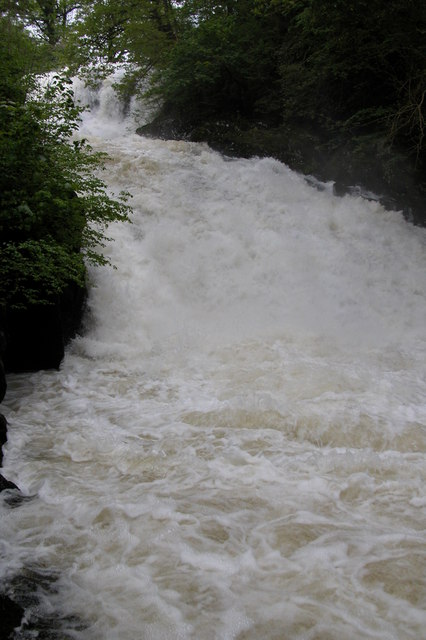
Swallow falls after heavy rain
by
Philip
Halling
|
|
Location: Swallow Falls,
Betws-Y-Coed, Caernarfonshire |
|
Grid Reference:
SH765576 |
Ceremonial County:
Carnearfonshire
 |
|
Map Link:
OS Get a map
StreetMap
|
Aerial photo: |
|
Getting there: Off the A5 between
Betws-y-Coed and Capel Curig |
|
Access: From parking on the side of the A5, or
in hotel car park opposite go through a turnstile and down some short paths
to viewing platforms. |
|
Website:
Own
|
|
Other Useful Websites:
Wiki
Image
North Wales Attractions
|
|
Email:
|
|
Address: Holyhead Road, Betws-y-Coed, Conwy |
|
Postcode: LL24 0DW |
Telephone: 01690 710770 (kiosk) |
Opening Times: Daily All Year. Access
via a turnstile.
Kiosk Manned from April-October. Apr-May & Sep-Oct 10am-3pm; June
10am-4pm;
July & August 9am-5pm |
|
Charges: April-Oct: Adult £1.50; Child 50p
when Kiosk manned.
All other times £1 in coin slot on turnstile |
|
Nearby Locations:
Conwy
Falls
|
Other Location Pages:
Waterfall
Waterfalls in Wales

 |
|
Notes:
|
|

|
Please let us know any other information that we
can add to the Grid(s) or page and any errors that you discover. Before making a long trip to any location it is always
wise to double check the current information, websites like magazines may be
correct at the time the information is written, but things change and it is of
course impossible to double check all entries on a regular basis. If you have
any good photographs that you feel would improve the illustration of this page
then please let us have copies. In referring to this page it is helpful if you
quote both the Page Ref and Topic or Section references from the Grid below. To print the
planning grid select it then right click and print the selected area.
Please submit information on locations you discover so
that this system continues to grow.
|