| Home | Newsletter | Locations | Diary |
| Indexes |
|
| Travellers Resource |
|
|
|
|
"A part of the World Heritage Site - Stonehenge, Avebury and Associated Sites" Silbury Hill is a large manmade hill that is
by the side of the A4 near
Avebury
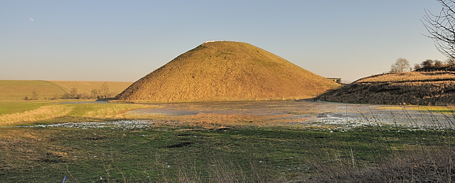
Silbury Hill in the winter Archaeologist estimated that there was 18 million man hours of work involved in its construction, the equivalent of 500 men working for 15 years. Its made up of 8.75 million square feet of material. The base of the hill is 550ft, (167 metres) in diameter, and the summit has a plateau 10ft or 30 metres across. The first phase material has been carbon dated to 2,750BC. A site was chosen for Silbury Hill that had a natural projection, and by cutting this off from the hillside and building on it, initially a small mound, this site was started, it was later greatly expanded. The first phase consisted of a gravel core with a riveting kerb of stakes and Sarsen boulders. Alternate layers of chalk rubble and earth were placed on top of this. The second phase involved heaping further chalk on top of the core, using material excavated from an encircling ditch. At some stage during this process the ditch was backfilled and work was concentrated on increasing the size of the mound to its present height using material from elsewhere. In the winter, the low-lying wide ditch area around it fills with water so that it is only joined to the land by a strip connecting to the road. Some think there is a spiral running up the side, you have this with some other hills, and it may have been a way to process or get to the top or it may have had some other significance. It also may have been a part of the construction allowing materials to be taken up. With the surviving steps near the top, if you follow the route around the hill you return to a position a few feet up or down suggesting these are the remains of a spiral. No one knows what its purpose was. As so much labour went onto creating it, we can assume it had some real significancew or use. Some suggest that there is another form of
energy, loosely based upon magnetic energies in the earth, that was the basis of
a lot of the ancient monuments and shaping of the land. There is some evidence
to support some of this with large underground containers constructed in some
places, rings of magnetic stones at
Stanton Drew
Over the years there have been many theories from it being a grave, but numerous excavations that nearly destroyed it, found nothing of consequence in it. Some have noted that there are a number of alignments between high hills where the steps cut into Silbury Hill near its top, line up with other hill heights, and that Silbury Hill is visible from many directions except when crops are ready to harvest. Another theory is that it was a giant sundial.
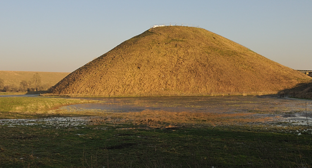
A closer view, this was taken while it was being restored, some of this can be seen on the top In 2000 a large hole appeared in the top of the
hill, and emergency work was needed, English Heritage at the same time decided
to do a more thorough investigation and renovation exercise. You can read all
about this and their findings at
www.english-heritage.org.uk/server/show/category.8613
English Heritage have another review of the
hill and surrounding landscape at
www.english-heritage.org.uk/server/show/category.1257,
In March 2007, English Heritage announced that a Roman village the size of 24 football pitches had been found at the foot of Silbury Hill. It contained regularly laid out streets and houses. As most Roman settlements were based upon or near existing major administrative centres, it seems likely that there was a sizable population somewhere very near to here at and prior to that time, that today we are unaware of. There is evidence of an extensive historic field system around Avebury that suggests it had a very high population in far earlier times. So while today its a large mound in the middle of the countryside, this could well have been the centre of society at that time. To put so much effort into its creation it must have had a significant role. West Kennet
Long Barrow
Please let us know any other information that we can add to the Grid(s) or page and any errors that you discover. Before making a long trip to any location it is always wise to double check the current information, websites like magazines may be correct at the time the information is written, but things change and it is of course impossible to double check all entries on a regular basis. If you have any good photographs that you feel would improve the illustration of this page then please let us have copies. In referring to this page it is helpful if you quote both the Page Ref and Topic or Section references from the Grid below. To print the planning grid select it then right click and print the selected area. Please submit information on locations you discover so that this system continues to grow.
|
||||||||||||||||||||||||||||||||||||
. |
||||||||||||||||||||||||||||||||||||
|
||||||||||||||||||||||||||||||||||||
|
|
||||||||||||||||||||||||||||||||||||