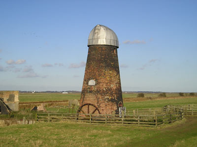
Lockgate Mill - Windmill
Also known as:
- Freethorpe Mill
- Banham's Black Mill
- Duffel's Mill
Freethorpe, Norfolk
Brick tower wind pump no sails
Lockgate Mill a is a wind pump located on
the Halvergate Marshes in the detached parish of Freethorpe within the
Norfolk Broads.
The current mill at this location was built
somewhere between 1800 and 1825 under the name 'Freethorpe Mill', it is four
storeys high and built of red brick tarred black. The structure stands at 35
feet to the curb and the diameter of the base is 24 feet, housing two doors
and 4 windows. A farm once stood next to the mill, it was known as Lockgate
Farm and was demolished in 1981 after many years of being derelict.
|

 Public domain image
 |
When operational, the mill was driven by
four patent sails that turned in a clockwise direction, these drove a 19ft
diameter external scoopwheel with 7 inch paddles. Unusually for a mill on
the halvergate marshes it didn't drain into the Halvergate Fleet even though
it is only 800 yards from the connection of the fleet with Breydon water.
Instead it drained Acle marshes that lie to the north of the mill.
The earliest recorded marshman of the mill was
a Mr Dan Banham, followed subsequently by Mr Bob Banham. The Banham family
ceased working the mill in the early 1920s and it was taken over for a short period
by Mr Gordon Addison, who lived in the nearby Lockgate Farm. The final marshman
that worked the mill was Mr Leonard Carter, who left the mill in the mid-1940s.
After Leonard Carter left the mill, it began to fall into disrepair. In 1953 the
sails were blown off the mill in a gale and was left to deteriorate until a
temporary aluminium cap was fitted in 1988 to protect the remains of the mill.
Today the mill still stands, and the aluminium
cap is still in situ, However in 2001 a fire broke out inside the mill, due to
vandals, this destroyed much of the remaining equipment on the inside of the
mill and has blackened some of the external and internal brickwork. The
scoopwheel is no longer in place, and remains of it can be seen beside the
outside of the structure. The mill can be directly reached on the Yarmouth-Berney
Arms path, however access is prohibited and a fence blocks access due to the
unsafe state the structure is in.
Further information Grid
|
Location: |
Lockgate Mill (Windmill) Freethorpe, Norfolk
|
|
Ceremonial County: |
Norfolk |
|
Grid Reference: |
TG 480072 |
|
Map Link: |
Multimap |
|
Aerial photo: |
Google aerial photo |
|
Route(s):
|
|
|
Best Times to Visit: |
|
|
E-mail: |
|
|
Website: |
|
|
Other useful
websites: |
|
|
Nearby Locations: |
|
|
Other Relevant pages: |
|
|
Classification: |
Windmill |
Date Updated: 04/2008 |
Planning Grid
|
Location: |
Lockgate Mill (Windmill) Freethorpe, Norfolk |
|
Grid Reference: |
TG 480072 |
|
Getting there: |
Approximately two miles west of Great
Yarmouth, and 3 miles east of Berney Arms on the northern edge of Breydon
Water. |
|
Access: |
The mill can be directly reached on the
Yarmouth-Berney Arms path, however access is prohibited and a fence blocks
access due to the unsafe state the structure is in. |
|
Parking: |
|
|
Facilities: |
|
|
Things To Do,
See and Photograph: |
|
|
What to take: |
|
|
Nature highlights: |
|
|
Address: |
|
|
Postcode: |
|
|
Telephone: |
|
|
Opening times: |
|
|
Charges: |
|
|
Photo Restrictions: |
|
|
Other Restrictions: |
|
|
Special Needs Access: |
|
|
Special Needs Facilities: |
|
|
Children Facilities: |
|
|
Dogs Allowed: |
|
|
CIN Page Ref: |
lockgate |
Date Updated: 04/08 |
Please let us know any other information that we
can add to the Further information and Planning Grids or page and any errors that you discover. Before making a long trip to any location it is always
wise to double check the current information, websites like magazines may be
correct at the time the information is written, but things change and it is of
course impossible to double check all entries on a regular basis. If you have
any good photographs that you feel would improve the illustration of this page
then please let us have copies. In referring to this page it is helpful if you
quote the CIN Page Ref at the bottom of the Planning Grid above. To print the
planning grid select it then right click and print the selected area.
Please submit information on locations you discover so
that this system continues to grow.
|