Segedunum Roman Fort
Baths and Museum (Wallsend)
Wallsend, Northumberland
|

Featured Location Guide
 |
|
Segedunum
Roman Fort stood on the banks of the River Tyne, the last outpost of
Hadrian's Wall.
For almost 300 years Segedunum, which means 'strong fort', was home to 600 Roman soldiers.
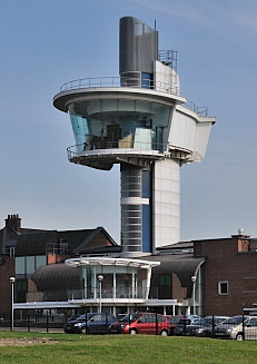
It is the most excavated Fort along the Wall and has a large interactive
museum, plus a 35 metre high viewing tower providing aerial views across this
site.
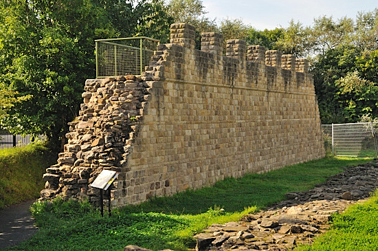
On the other side of the road is a reconstruction of a piece of wall as they
think it looked, that you can climb onto. In the grounds of the fort is a
reconstruction of a roman bathhouse.
Picture:- The 35m
viewing tower |
  |
 
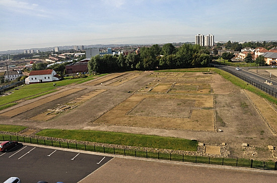
View from Tower, the bathhouse is white building
on left
If you look at the aerial photos on either
Multimap
 or
Google or
Google  you will
see the layout of this fort, now with a road running across a part of it.
The piece that you pay to go in to is the larger piece, you also have a
museum, a 35 metre high viewing tower where you can go to get an aerial view of the site and the reconstruction of
a bathhouse. On the ground you see a plan, there is hardly any stonework.
This is not the ideal site to go to expecting to be impressed by the roman
remains but perhaps as a wider study of forts and their layout, plus the
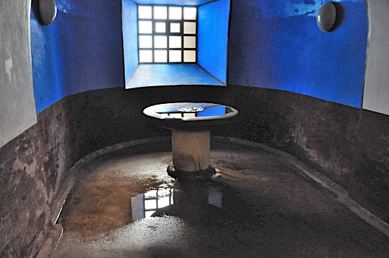
chance to see the reconstructed bathhouse. The bathhouse is opened up at
set times, rather than being available all the time. you will
see the layout of this fort, now with a road running across a part of it.
The piece that you pay to go in to is the larger piece, you also have a
museum, a 35 metre high viewing tower where you can go to get an aerial view of the site and the reconstruction of
a bathhouse. On the ground you see a plan, there is hardly any stonework.
This is not the ideal site to go to expecting to be impressed by the roman
remains but perhaps as a wider study of forts and their layout, plus the
chance to see the reconstructed bathhouse. The bathhouse is opened up at
set times, rather than being available all the time.
The
Roman wall was originally to be built from a point at
Pont
Aelius
 at
Newcastle upon Tyne, and to proceed west. It was later decided
to extend it 4 miles to the east to Wallsend, 5 years later in about 127AD
this was probably done so as to protect the
river crossing at Pont Aelius.
 The new section of wall was built in the narrow width used further west. A
section of wall ran from the fort out into the river, which is tidal to at
least the lowest tidal point. An extensive civilian community grew up
around the fort, including unusually an area to the north of the wall.
It is not known who was first stationed at Segedunum, however we do know that in the second century the Second Cohort of Nervians
was stationed there. In the third and fourth centuries the part-mounted Fourth
Cohort of the Lingones occupied the fort, as recorded in the
Notitia Dignitatum. Both units were 600 strong, 120 cavalry and 480 infantry.
 
Within the Bathhouse
After around 400AD, the fort was abandoned and
became farming country. In the 18th century coal mines were sunk in the area,
and this became a pit village. In 1884 the whole fort was covered in terraced
housing.
The Segedunum Project did not start until 1997,
when there were a series of excavations around the fort, as well as the
conversion of a former Swan Hunter shipyard building into a museum and the
building of the Bathhouse. This site first opened to the public June 2000.
A large 35metre high observation tower has also been constructed to overlook the
site.
 
The reconstructed section of
wall that you can climb,
to the right at ground level the remains of the wall,
this is across the road and outside the attraction.
See the
 for more images.
.
Planning Grid
|
Location: |
Segedunum
Roman Fort, Wallsend, Northumberland |
|
Grid Reference: |
NZ301660
 |
|
Getting there: |
Segedunum is based on Buddle Street in
Wallsend. |
|
Access: |
Access from car park |
|
Parking: |
Own FREE car park |
|
Facilities: |
|
|
Things To Do,
See and Photograph: |
Ground plan of fort, reconstructed bathhouse,
shipping etc on river, aerial view from viewing tower. |
|
What to take: |
|
|
Nature highlights: |
Unlikely |
|
Address: |
Segedunum Roman Fort, Baths & Museum
Buddle Street
Wallsend
North Tyneside |
|
Postcode: |
NE28 6HR |
|
Telephone: |
0191
236 9347 |
|
Opening times: |
1 April-31 October: Monday-Sunday 10am-5pm
1 Nov-31 March: Monday-Sunday 10am-3pm
Closed: 25 & 26 December & 1 January. |
|
Charges: |
Adults £4.35;
Concessions £2.60; Child (under 16) FREE |
|
Photo Restrictions: |
None |
|
Other Restrictions: |
None I am aware of |
|
Special Needs Access: |
level site, modern museum with full access,
lifts etc. |
|
Special Needs Facilities: |
everything you are likely to need |
|
Children Facilities: |
yes |
|
Dogs Allowed: |
Guide dogs only |
|

|
Please let us know any other information that we
can add to the Further information and Planning Grids or page and any errors that you discover. Before making a long trip to any location it is always
wise to double check the current information, websites like magazines may be
correct at the time the information is written, but things change and it is of
course impossible to double check all entries on a regular basis. If you have
any good photographs that you feel would improve the illustration of this page
then please let us have copies. In referring to this page it is helpful if you
quote both the Page Ref and Topic or Section references from the Grid below. To print the
planning grid select it then right click and print the selected area.
Please submit information on locations you discover so
that this system continues to grow.
|