Coventina's Well
nr Carrawbrough, Northumberland
|

Location Guide |
Coventina's Well - or boggy ground
Located behind (to the
south west of)
Brocolitia
Roman Fort, which is just humps and bumps and to the west of
The
Temple of
Mithras.
Coventina's Well
From the car park you go through a field and
round behind the fort remains and come across the
Temple of
Mithras,
 then there is a
path, above left that goes to a stile and this goes into a walled enclosure
with a path through, above right, that is very boggy and I think is the
location of Coventina's well. This also lines up with the
description below from J Collingwood Bruce's Handbook to the Roman
Wall. then there is a
path, above left that goes to a stile and this goes into a walled enclosure
with a path through, above right, that is very boggy and I think is the
location of Coventina's well. This also lines up with the
description below from J Collingwood Bruce's Handbook to the Roman
Wall.
| "When the area
was excavated in 1876, the top was choked with stones. Below came a
mass of coins, followed by carved stones, altars, more coins, jars and
incense-burners, pearls, brooches and other votive objects in an
indiscriminate mass. In total, [John] Clayton retrieved 13,487 coins
(four of gold, 184 of silver and the rest of bronze). The well was
dedicated to a water-goddess named Coventina." |
 
  |
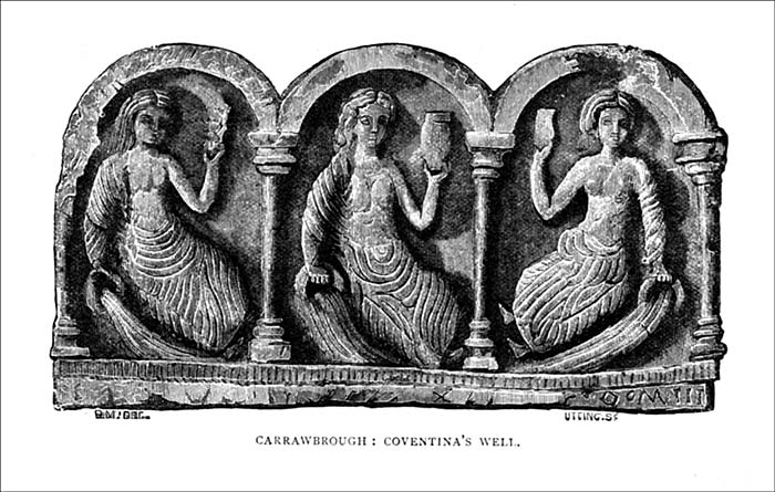
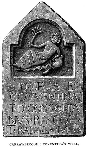
Images above and to the
left are of from a book of holly wells in England (copyright expired) and show two of the
items found at Coventinas Well, these gave it
its name. These were discovered
by John Clayton and can be found now in the museum at
Chesters Roman
Fort,
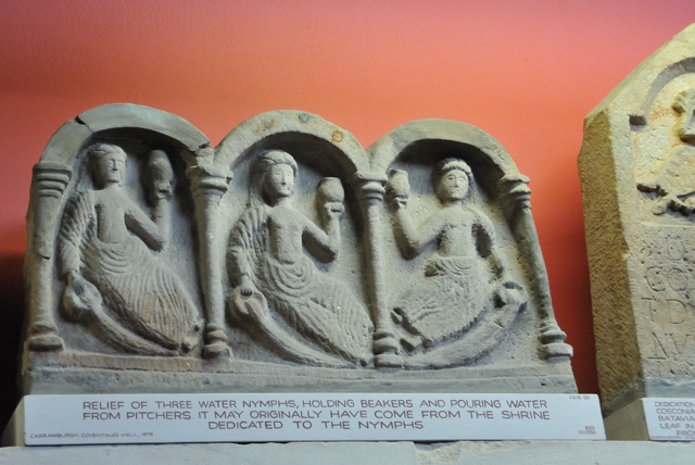
 where most of his finds like this are displayed. where most of his finds like this are displayed.
See photo below. |
 
One of the stones above with the
edge of the second shown,
photo taken in the museum at
Chesters Roman
Fort

|
Location: Coventina's Well, nr Carrawbrough,
Northumberland |
Grid Reference:
NY858712
 |
Ceremonial County:
Northumberland |
|
Map Link:
Multimap

|
Aerial photo:
Multimap
 |
|
Getting there: Parking for this is on the side
of the B6138 west of Chollerford.
Parking in a layby by the side of the road,
unusual in that it has a pay and display meter. |
|
Access: From the layby you can see the humps and bumps
of the covered over Roman fort of Brocolitia. Going down the left hand side of the fort, and
around behind it, there are no marker signs, you come upon the temple, you will then see the path that leads to the well. The
first field I went through had beef cattle and the one the temple and fort were in had sheep. Many who stopped were not prepared to go
through the cattle, and most of the time I was looking around, other then for
the workmen pumping out the temple, I was on my own. |
|
Website: |
|
Other Useful Websites:
EH  (Corrected) TR (Corrected) TR  Wikipedia

Geograph including good images
|
|
Email: |
|
Address: |
|
Postcode: |
Telephone: |
|
Opening Times: Access at all times, but as you
have to pass through fields with livestock its best to do this when its
light. |
|
Charges: FREE - but there is for some reason a
pay and display machine on the layby. |
Nearby Locations:
Temple of
Mithras
 Brocolitia
Roman Fort
 |
Other Location Pages:
Hadrian's Wall Route Guide
 |
|
Other Relevant Pages: Roman Frontiers
 Hadrian's Wall
Hadrian's Wall - Featured Places

|
|
Notes: |
|

|
Please let us know any other information that we
can add to the Grid(s) or page and any errors that you discover. Before making a long trip to any location it is always
wise to double check the current information, websites like magazines may be
correct at the time the information is written, but things change and it is of
course impossible to double check all entries on a regular basis. If you have
any good photographs that you feel would improve the illustration of this page
then please let us have copies. In referring to this page it is helpful if you
quote both the Page Ref and Topic or Section references from the Grid below. To print the
planning grid select it then right click and print the selected area.
Please submit information on locations you discover so
that this system continues to grow.
|