| Home | Newsletter | Locations | Diary |
|
Indexes |
|
|
|
|
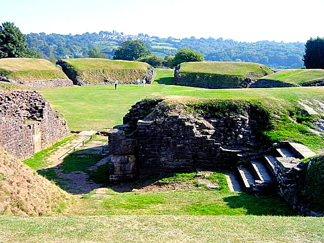
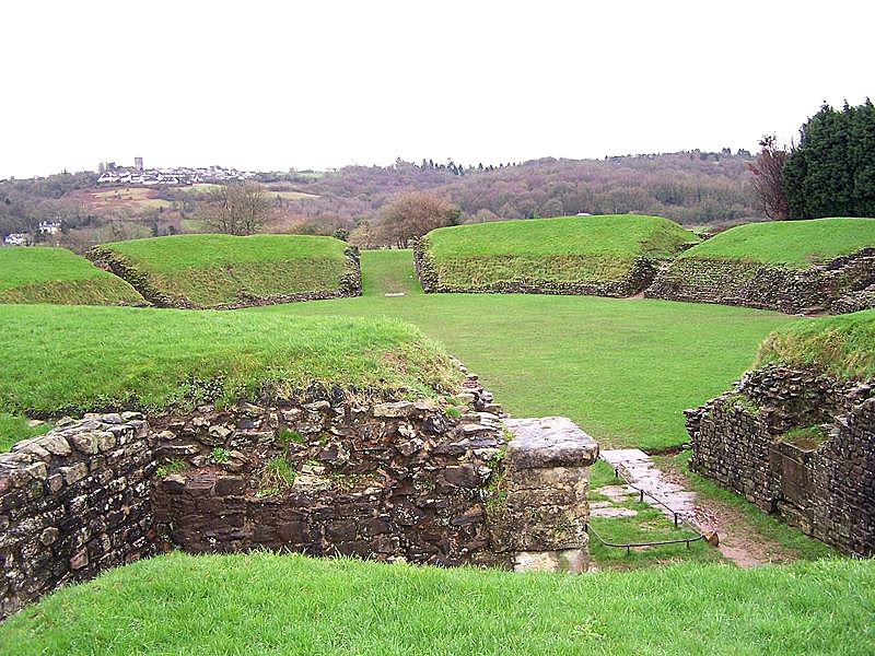
Overview It was the base of one of the major Roman legions in Britain, and said to be the base of a 'bishipree' greater than Canterbury or York until it was moved to St Davids.
The Roman Baths Museum nearby uses modern technology to give the visitor a vivid image of its former grandeur. The museum is run by CADW, so opening times are not exactly the same as the Legionary Museum also there is an entry charge. A heritage trail takes you around a larger selection of local sites as well as calling on the main sites. The trail itself is said to take about an hour, but you need longer to visit the sites along it. Connection with King Arthur:- In early versions, including all by Geoffrey on Monmouth this was clearly stated as Arthur's base, Camelot was not mentioned, nor was the round table. In more detail Caerleon, was the location of the ancient Roman Military Fortress of Isca. Founded about 74AD, where the Second Augustan Legion encamped beside the River Usk in a strategic position, surrounded by sheltering hills and a wide sweep of navigable river. The Fortress took its name from the river; known by the Celts as Yr Wysg. Following to the Roman withdrawal, Caerleon maintained its importance as a seat of the Welsh Princes, and as a trading and industrial centre up to the end of the Nineteenth Century. The town has suffered the ravages of time and has been ransacked by Danes, Vikings, Saxons and Welsh. Between the Hanbury and the river lie the remains of the ancient quay, wharf and slipway. The earliest record of Caerleon as a port after Roman times comes under a charter given by His Most Excellent Majesty King Edward II in 1324. In the last century, also found here was the terminus of the Ponthir and Caerleon tramroad, built by the Ironmasters to carry iron ore from the valleys to the iron foundries and tinplate from the works to the wharf for shipment to Bristol. The tramroad was originally built to connect Caerleon forge with the wharf, but it was extended north to Ponthir tinplate works. By 1812 it was further extended, linking with the Monmouthshire Canal at Halfway House, Cwmbran. The tramroad was closed about 1865. From Roman times at least, probably well before, there was cross channel trade with Bristol. It ended in 1896 when the last ship left the quayside. Due to the building of the Monmouthshire Canal and Newport Docks, Newport had become the commercial centre of Monmouthshire. Had the canal projected in 1792 between Brecon and Caerleon, via Usk, been constructed, Caerleon may well have retained importance for a longer time. The project was abandoned and in 1800 the building of the stone bridge in Newport prevented large ships from reaching Caerleon. Beside the Hanbury Arms are the remains of the Round Tower, a part of the castle. Also forming a fortified Round Tower guarding the old bridge, there was another tower on the opposite bank, but this no longer exists. In the High Street, Caerleon House can be found, a large house with sash windows. Built about 1760 on the site of the Roman East Gate. The courtyard of this house is also the site of the Ffwrwm Arts and Crafts Centre with its unique sculpture gardens. Don't miss the thrones of King Arthur, Queen Guinevere and the ancient stone-carved bull's head with supposed magical qualities. Opposite Caerleon House is Mynde House, previously named Castle Villa, a stone house built by John Jenkins, Tin Plate Master of Ponthir Works and part-owner of Caerleon Works, it was built in 1820 . He built high walls and the battlemented turrets around the four acres of the Motte and Bailey and remains of the Castle. It is said he did this to protect himself and his family from possible attack by members of the Chartist movement who had been campaigning throughout the country for the reform of Parliament and the achievement of certain democratic rights. In 1870 the house passed to Thomas Woollet who started building an extra storey, but was prevented from completing it by the owner of Caerleon House on the grounds of "Ancient Lights". Leaving to this day the house with an unusual front.
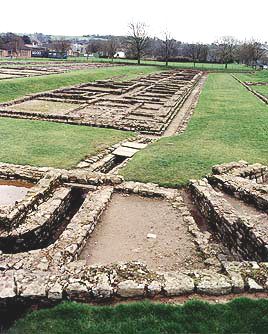
Roman Legion Museum:- A group of antiquaries and others formed the local Antiquarian Association in 1847, so as "to form a Museum of Antiquities found in Caerleon and the neighbouring district and the furtherance of any antiquarian pursuits whether by excavation or otherwise." The neo-Greek external appearance reflects the interest of the period in classical architecture, later in 1936 it was given to the National Museum of Wales. The museum was extensively re-built and refurbished to its present appearance in 1987. Next to the Museum is the Capricorn Centre, an educational facility for visitors and school children. Admission to the Museum is free (as is entry to all National Museum & Galleries of Wales sites). Roman Baths:- The Roman baths complex at Caerleon, was as good as any. It contained an open air swimming pool, a series of hot, warm and cold baths, exercise yard, heated changing room and exercise hall. Nowadays the entire site, in a modern building, can be viewed from an elevated walkway. Informative light and sound displays explain how the baths would have been originally. There is an entry charge for the baths museum only. Sections of the Roman fortress wall still survive. Hill Fort:- Just outside Caerleon, not on the walking route around Caerleon,
and not on the normal tourist trail, you will find an Iron age hill fort known as Lodge
Hill Fort/Lodge Wood Camp. The Romans built a road
from the North Gate of Caerleon right up to the fort and used the hill-top as a
summer camp. For more details and how to find it, see the location guide for the
hill fort
Lodge Hill
Fort. One of the best ways to see Caerleon is by taking the walking
trail, it takes
around an hour plus extra time to look in more detail at each of the roman sites
above. You can get a map and write up of what you will see
from
www.caerleon.net/intro/heritage.htm
Please let us know any other information that we can add to the Further information and Planning Grids or page and any errors that you discover. Before making a long trip to any location it is always wise to double check the current information, websites like magazines may be correct at the time the information is written, but things change and it is of course impossible to double check all entries on a regular basis. If you have any good photographs that you feel would improve the illustration of this page then please let us have copies. In referring to this page it is helpful if you quote both the Page Ref and Topic or Section references from the Grid below. To print the planning grid select it then right click and print the selected area. Please submit information on locations you discover so that this system continues to grow.
|
||||||||||||||||||||||||||||||||||||||||||||||||||||||||||||||||||||||||||||||
|
||||||||||||||||||||||||||||||||||||||||||||||||||||||||||||||||||||||||||||||
.
|
||||||||||||||||||||||||||||||||||||||||||||||||||||||||||||||||||||||||||||||
|
|
||||||||||||||||||||||||||||||||||||||||||||||||||||||||||||||||||||||||||||||