Maes Howe
also written Maeshowe
Stegness, Orkney, Scotland
|

Location Guide |
"A part of the World
Heritage Site - Heart of Neolithic Orkney"
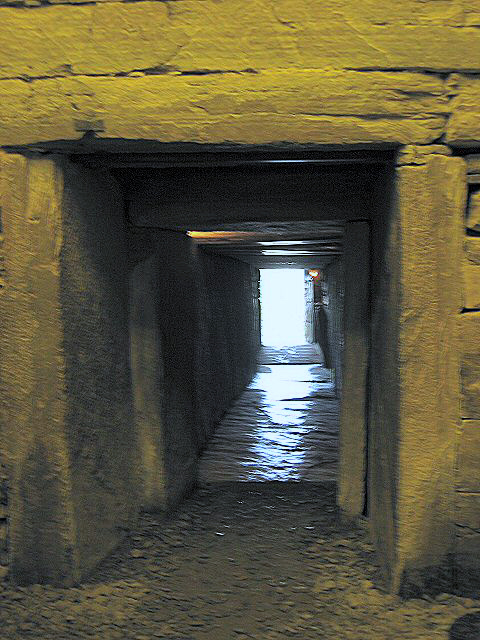
Maes Howe showing entrance Photo By
Colin Smith


A chambered cairn and passage grave of a
similar design to Newgrange in
Ireland. It is a part of the World Heritage Site including a number of
Neolithic features on Orkney. These together are said to represent the second most
significant collection of Neolithic sites after the
Stonehenge
 and
Avebury
area, in the UK.
I think I would need to add
Stanton Drew,
however
allowing for this and realising Stonehenge and Avebury are some way a part and
really two areas, its still the 4th most significant area. and
Avebury
area, in the UK.
I think I would need to add
Stanton Drew,
however
allowing for this and realising Stonehenge and Avebury are some way a part and
really two areas, its still the 4th most significant area.
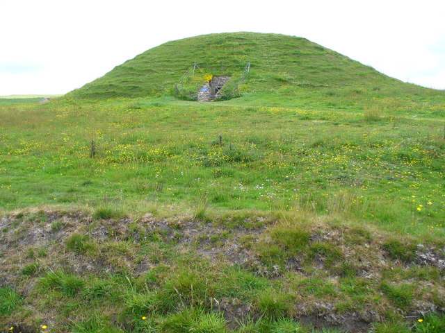
It is a grass mound rising from a flat area at the east end of the
Loch of Harrey. The mound is 115ft (35 metres) across and 24ft high (7.3 metres),
and 50-70 feet away from the mound is a ditch 45ft across, and
banks.
|
The mound is over a complex of passageways and large stone slabs
some weighing up to 30 tons. The alignment is such that at the mid
winter solstice (21st December) and 3 weeks either side of it, light goes down the entry tunnel
illuminating the rear
wall. The same occurs at Newgrange. The sun’s rays align with a standing
stone, the Barnhouse Stone, standing 800m SSW of Maes Howe.
The entry passage is 36ft long, and about 3ft high, and leads to a
central beehive shaped chamber currently 12.5ft high, 4.7 meters across, its said that the
original height may have been 15ft or as high as 20ft. It is
necessary to stoop or crawl to reach the chamber.
There is a recess in the passage side that contains a blocking stone
that would allow those inside to seal off the outside world from view.
The blocking stone however leaves a gap 4.7 inches to the top of the
passage roof. There are some suggestions that this may have formed a lightbox, and with other parts allowing a camera obscurer like image to be
created. |

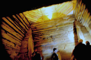
Entry passage
from inside

By
Bob
Burke
|
|
The central chamber has square buttresses in the corners sticking
into the chamber. The side walls start off upright, as is the whole of
the rear wall. There are three smaller side areas off on each side
around the centre of the upright sections off the side walls and one off
the rear wall.
There are other tombs of a similar type called 'Maeshowe
type' on Orkney, but this is the largest and most complex of these.
Central Chamber by Malcolm Morris
|
|
There is an optical peculiarity in the geographic location, in that for a
period around 20 days each side of the winter equinox the sun sets behind
the hill, but then due to its course peeks out again around a lower point before
finally setting. This generally occurs on December 1st and on January
10th, the sun disappears for 7 minutes then reappears for a minute.
This dates from Neolithic times around 2,800BC, but was robbed by the Vikings
in the about the 12th century, lead by Viking Earl Harald Maddadarson and Ragnvald,
First Earl of Mere. Over 30 runic inscriptions on the walls are the worlds
largest collection of this writing form.
A Neolithic low road connects it with the preserved
village of
Skara
Brae
passing near the
Ring of
Brodgar Stone Circle,
and
Stenness
Stone Circle.
Low roads are often found across Britain connecting ritual sites.
|
It is thought that there may have been
a large stone circle around Maes Howe.
At the standing stones of Stenness there
are two large flat stones with gaps between, this aligns so that Maes
Howe is in the gap between. Its not known if there is any
significance in this.
Maes Howe was taken into state care in
1910 and given a concrete roof and top rounded off, before this it had a
different appearance and according to an 1862 sketch had a hole in the roof
that people used to access it, before the entrance tunnel was unblocked,
the damage being done that created the hole by earlier excavations. |
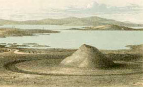
As at 1862
 |
|
Location: Maes Howe, Stegness, Orkney,
Scotland |
|
Grid Reference: HY318127 |
Ceremonial County:
Orkney Isles |
|
Map Link:
Multimap
|
Aerial photo: |
|
Getting there: On the main island of Orkney |
|
Access: Public access. Access to Maeshowe is via a 12 metre length narrow passageway measuring 1.19
metres high by 0.7 metres wide. |
|
Website:
www.maeshowe.co.uk/
|
|
Other Useful Websites:
Historic-Scotland.
Orkney
Wikipedia
Geograph Images
www.orkneyjar.com/history/maeshowe/
Orkney tourist board
www.megalithic.co.uk/shop/maes_howe_video.htm
|
|
Email: |
|
Address: |
|
Postcode: KW16 3HA |
Telephone: (01856) 761606. |
|
Opening Times: Open 9.30am-5pm in the
summer months; 9.30-4pm in the winter.
Although the visitor centre closes at 5pm in summer, some tours may also
start at this time.
Twilight tours in June, July and August 6PM, 7PM and 8PM
Booking in advance is
required
Admissions to Maeshowe are through a timed ticket that gives a set time for
the start of the guided tour at Maeshowe. All visitors are required to book
in at Tormiston Mill which is the Visitor Centre for Maeshowe.
You
may reserve a time in person at Tormiston Mill or by requesting any other
Historic Scotland Site to contact them on your behalf.
Tickets can only be obtained on the day from Tormiston Mill Visitor Centre:
Tormiston Mill Visitor Centre
on
01856 761 606 or
Skara Brae on 01856 841 815.
Tours are usually on the hour and last an hour, but check for latest
details. Maximum number per tour is 20 See
tour detail page
|
|
Charges: Maeshowe is managed by Historic
Scotland and offers hourly tours.
Free to Historic Scotland members.
English Heritage members FREE second
membership year plus, 50% off in first year.
Others: Adult £5.20; Child £2.60;
Concession £4.20 |
|
Nearby Locations:
Ring of
Brodgar Stone Circle,
Orkney
Stenness
Stone Circle, Orkney
Skara
Brae
– settlement Orkney
|
|
Other Location nearby: see
tourist board page
on this
section of the island |
Other Relevant Pages:
World
Heritage Sites
in the UK

World
Heritage Sites
 World
Heritage Sites - Further Information
World
Heritage Sites - Further Information
|
|
Notes: During the winter solstice every year the sun
shines down the long entrance passage and lights up the back wall. This
occurrence has become so celebrated that it can even be witnessed on the
internet at www.maeshowe.co.uk
For parking other than cars call 01856
761 606. |
|

|
Please let us know any other information that we
can add to the Grid(s) or page and any errors that you discover. Before making a long trip to any location it is always
wise to double check the current information, websites like magazines may be
correct at the time the information is written, but things change and it is of
course impossible to double check all entries on a regular basis. If you have
any good photographs that you feel would improve the illustration of this page
then please let us have copies. In referring to this page it is helpful if you
quote both the Page Ref and Topic or Section references from the Grid below. To print the
planning grid select it then right click and print the selected area.
Please submit information on locations you discover so
that this system continues to grow.
|