Old Sarum,
Wiltshire
|
  |
 |
|
To see the
bigger pictures click on the image you want to look more closely at. |
  |
Old Sarum
earthwork attracted William the Conqueror.
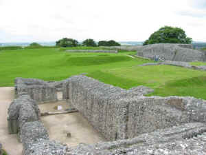
It is the remains of a prehistoric Royal palace,
Norman castle and cathedral not far from Salisbury in Wiltshire. Today it
is a great earthwork with a huge bank and ditch.
Old Sarum was originally built by the people of the Iron Age around 500BC. The
Romans, Saxons and Normans have all been resident in what is now known as
Old Sarum.
In 1070 it was the base William the Conqueror used to pay off his army
and by 1085 it is where he demanded loyalty from his nobles. A Norman castle,
cathedral and Royal Palace were built inside, but disputes between priests and
soldiers, together with an inadequate supply of water were all to play a
part in its downfall. |
  |
In 1226 the city of New Sarum, or what we know today as
Salisbury, was created. The old cathedral was dismantled and used to build
the new one in Salisbury, which has been made famous by the paintings of
John Constable. The castle at Old Sarum remained in use until Tudor times.
It is a beautiful site on top of a hill and when standing on the top of
one of it's mounds you can see the surrounding chalk countryside landscape
all around and in the distance on a good day the new cathedral in
Salisbury can be seen. |
What
you see when you arrive
We parked the car in the car park and walked
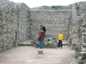
across the footbridge over the dry moat. Inside the main walls there was a
small shop and some ruins of a village that existed a long time ago. You had to
have a very good imagination to put together a picture of what it would have
been like to have lived here in the day it was active.
It
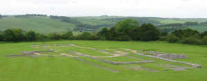
was also the site of the original Salisbury Cathedral and in the grass you could
see the outline of where the original structure was. From the raised earthworks
surrounding the site looking, south, you could see the existing Salisbury
Cathedral in the valley below.
Pictures were taken in 2002 prior to Nikon DSLR
- hope to update them sometime.
|
Planning Grid
|
Location: |
Old Sarum,
Wiltshire |
|
Grid Reference |
SU 138327 - OS
Map 184 |
|
Map Link: |
VIEW MAP |
|
Getting there: |
2 miles north
of Salisbury off the A345. |
|
Access: |
From car park
walk across moat via steep wooden bridge into main entrance and site has chalk paths. |
|
Parking: |
It has it's
own free car park 50m from entrance via loose gravel surface and steep
wooden bridge with non slip surface. |
|
Facilities: |
Toilets.
Disabled access to outer bailey and grounds only, there is a disabled
toilet. |
|
Things To Do,
See and Photograph: |
Remains of
prehistoric fortress and Norman Palace, castle and cathedral. Also views
across the chalk plains. |
|
What to take: |
Camera,
Tripod, Grads, Panorama kit |
|
Nature watching: |
|
|
Best Times to
Visit: |
|
|
Address: |
Old Sarum,
Salisbury Wiltshire |
|
Postcode: |
SP1 3SD |
|
Telephone: |
01722 335398 |
|
E-mail: |
|
|
Website: |
www.english-heritage.org.uk/oldsarum
|
|
Opening times: |
1 Mar-31 Mar
and 1 Oct-31 Oct Daily 10am to 4pm
1 Apr -30 Jun and 1 Sep-30 Sep daily 10am to 5pm
1 Jul-31 Aug daily 9am to 6pm
1
Nov-29 Feb daily 11am to 3pm
Closed 24-26 Dec and 1 Jan |
|
Charges: |
English
Heritage Members - Free; Non-Members Adults £2.90; Concession £2.20: Child
£1.50 |
|
Photo
Restrictions and Copyright: |
No commercial
photography is allowed in all their grounds, it is not permitted in some
buildings for conservation purposes, usually a no photography symbol is
present on entry to the building where this restriction is in place. |
|
Other useful
websites: |
|
|
CIN Page Ref: |
OldSarum |
Please let us know any other information that we
can add to this Planning Grid or page and any errors that you discover. All our
information is only as up to date as members have provided, so please remember
to tell us of any errors or updates so that we can all benefit by sharing our
knowledge and experience. Before making a long trip to any location it is always
wise to double check the current information, websites like magazines may be
correct at the time the information is written, but things change and it is of
course impossible to double check all entries on a regular basis. If you have
any good photographs that you feel would improve the illustration of this page
then please let us have copies. In referring to this page it is helpful if you
quote the CIN Page Ref at the bottom of the Planning Grid above. To print the
planning grid select it then right click and print the selected area.
Please submit information on locations you discover so
that this system continues to grow.
|