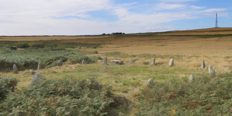
Tregeseal East Stone Circle
Cornwall
Also known as the Tregeseal
Dancing Stones.
Click on
Images to see a larger version
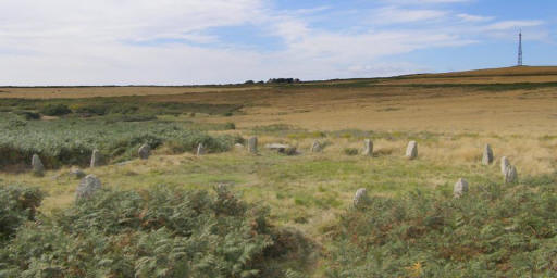 |
A restored prehistoric stone circle around one mile northeast of the town of
St Just in the Penwith district of Cornwall.
It is the one surviving circle of three that once stood aligned along an
east-west axis on the hillside to the south of Carn Kenidjack
The nineteen granite stones are also known as The Dancing Stones.
 See here for Picture Details
|
|
|
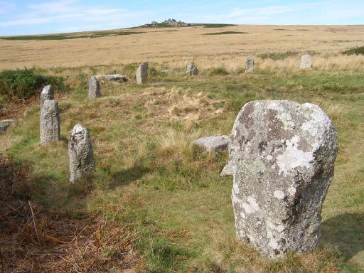 |
Some say it
originally had around 19 stones in a ring approximately 22m in diameter.
Today thirteen silver-grey stones remain.
All the stones are about 1m high, the tallest
of which stands 1.3m. There is a vantage point on a large stone which makes
up part of a wall about 15m to the south west. From here the white stones of
the circle can be seen more clearly, even in the dense bracken.
Tregeseal is part
of a double circle, it's partner, Tregeseal (West) was set on an east-west
alignment but the later has now been destroyed and no longer visible. In many
cases there is a third but I can't find any record of another. (I
have come across Tregeseal Central recorded by aerial photography to the west).
See here for Picture Details |
A copy of a diagram showing it pre restoration can be seen at
http://www.pznow.co.uk/historic1/stonecircles.html
Tregeseal holed stones is nearby at SW388326 -
a row of three
holed stones. Associated with this row are two other holed stones nearby. These
two stones are composed of different igneous rock. Both have been broken but now
are restored. See
http://www.pznow.co.uk/historic1/holedstones.html#Tregeseal%20Holed%20Stones%20SW388326
Click on
Images to see a larger version
See also
Our
section on stone circles
The discussion on the purpose of stone circles
Planning Grid
|
Location: |
Tregeseal East Stone Circle,
Tregeseal, Cornwall |
|
Grid Reference |
SW387324
OS
Map 203 |
|
Map Link: |
Multimap
Google maps aerial photograph |
|
Getting there: |
Drive up through
the village to the end of the tarmac. Park and follow sign up track rather
than across fields on footpath. Pass the farm and hit the mud! The stones
are now surrounded by a good covering of bracken. |
|
Access: |
Some signs - Just past the farm on the right
is a plaque with an arrow pointing the way. |
|
Parking: |
Roadside at end of tarmac road. |
|
Facilities: |
|
|
Things To Do,
See and Photograph: |
|
|
What to take: |
|
|
Nature highlights: |
|
|
Best Times to
Visit: |
|
|
Address: |
|
|
Postcode: |
|
|
Telephone: |
|
|
E-mail: |
|
|
Website: |
http://myweb.tiscali.co.uk/celynog/Cornwall/tregeseal.htm |
|
Opening times: |
Ppen at all times |
|
Charges: |
none |
|
Photo Restrictions: |
none |
|
Other Restrictions: |
none |
|
Special Needs Access: |
|
|
Special Needs Facilities: |
|
|
Children Facilities: |
|
|
Dogs Allowed: |
No information, but no restrictions expected
except around sheep. |
|
Other useful
websites: |
|
|
CIN Page Ref: |
tregeseal_east_stone_circle |
Date Updated:03/08 |
Please let us know any other information that we
can add to this Planning Grid or page and any errors that you discover. Before making a long trip to any location it is always
wise to double check the current information, websites like magazines may be
correct at the time the information is written, but things change and it is of
course impossible to double check all entries on a regular basis. If you have
any good photographs that you feel would improve the illustration of this page
then please let us have copies. In referring to this page it is helpful if you
quote the CIN Page Ref at the bottom of the Planning Grid above. To print the
planning grid select it then right click and print the selected area.
Please submit information on locations you discover so
that this system continues to grow.
|