Pitstone
Windmill
nr Pitstone, Buckinghamshire
|

Featured Location Guide |
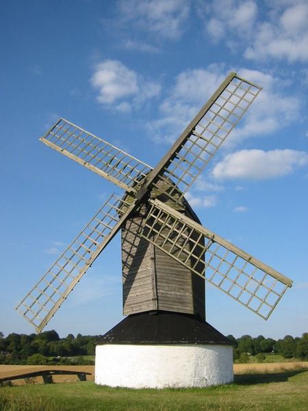
An example of the earliest
form of Windmill, postmill. Constructed from 1627, possibly before.
It is thought to have been first built
about 1627 as this date is carved on part of the framework. This is the
earliest date to be found on any windmill in the British Isles. It should be
remembered that such a structure would have had to have frequent repairs
made to it, so it is quite possible the mill predates 1627. The design of the mill is what is known as a post-mill. This means the whole
superstructure of the mill rests on one main post. This post arises from
ground level through brick and a foundation chamber; the post then acts as a
pivot for the timber built structure above with the sails. Consequently, the
upper section of the mill and sails could be turned towards the direction of
the wind (reinforcements added in the 20th century now prevent the upper
section from turning). The mill machinery in the upper rotating section was
reached by a long flight of external steps. For many hundreds of years grain grown in the two adjoining villages was
ground at the mill into flour. In 1874 the mill was bought by Adelbert
Wellington Brownlow Cust, 3rd Earl Brownlow who owned the nearby Ashridge
Estate. He subsequently let it to a local farmer, who ran a successful
milling business from the mill. |

Temporary picture, perspective problem, will be replaced when we get a
chance to go and photograph this windmill. |
|
In 1902 the mill was seriously damaged during an enormous gale, damaging it
beyond the price of economic repair. Around 1922 the derelict ruined mill
was bought from the Ashridge Estate by a farmer whose land was close to the
mill. In 1937 he donated it to the National Trust. However, it was not until
1963 that a band of volunteers began to carry out renovations at their own
expense. In 1970, after an interlude of 68 years, the mill once again ground
corn.
Information from Wikipedia |
.
Planning Grid
|
Location: |
Pitstone Windmill nr Pitstone, Buckinghamshire |
|
Grid Reference: |
SP 945157 Map 181 |
|
Getting there: |
½ml S of Ivinghoe, 3ml
NE of Tring, just W of B488 |
|
Access: |
Nearby paths, and track appears to go by it,
no apparent trees around. |
|
Parking: |
|
|
Facilities: |
No WC |
|
Things To Do,
See and Photograph: |
Windmill - clear location, and in field views.
No trees around as far as I can see |
|
What to take: |
Telephoto lens if looking from paths |
|
Nature highlights: |
Country location so wildlife probable. |
|
Address: |
|
|
Postcode: |
|
|
Telephone: |
01442 851227 |
|
Opening times: |
National Trust -
volunteers open Sundays 1 Jun-31 Aug 2:30pm-6pm. Call before to check it
will actually be open. |
|
Charges: |
Free To NT members -
others £1.50 adults, Children 70p |
|
Photo Restrictions: |
None from public paths |
|
Other Restrictions: |
None known |
|
Special Needs Access: |
Take a look at aerial photographs to get an
idea of landscape. Appears not too difficult. |
|
Special Needs Facilities: |
none |
|
Children Facilities: |
|
|
Dogs Allowed: |
No known restrictions |
|

|
Please let us know any other information that we
can add to the Further information and Planning Grids or page and any errors that you discover. Before making a long trip to any location it is always
wise to double check the current information, websites like magazines may be
correct at the time the information is written, but things change and it is of
course impossible to double check all entries on a regular basis. If you have
any good photographs that you feel would improve the illustration of this page
then please let us have copies. In referring to this page it is helpful if you
quote both the Page Ref and Topic or Section references from the Grid below. To print the
planning grid select it then right click and print the selected area.
Please submit information on locations you discover so
that this system continues to grow.
|