Verulamium
St Albans, Hertfordshire
It is believed that Verulamium was the third-largest city in Roman Britain.
It was sited to the southwest of St Albans and is now park and agricultural
land, though parts have also been built on. A large portion of the city remains
unexcavated. It was built beside the River Ver. There are a few remains of the
Roman city visible today, such as parts of the city walls and a hypocaust and
theatre.
A roman settlement since around 50AD it grew to a significant township by the
early 200's when it covered about 125 acres behind a deep ditch and wall.
Amongst its structures it had a forum, basilica and a theatre, most of which
were destroyed by fires in 155AD and again in 250Ad. The town itself being
rebuilt at least twice over the next 150 years. By around 300 it is believed up
to ten aristocratic families had estates here. The Romans left the city somewhen
between 400 and 450AD. Much of the building materials on the site were re-used
in the building of St Albans, much of it believed to have been used in the
building of the Norman Abbey. Much of St Albans and its environs is built over
Roman remains and in the 1970's a complete tile kiln was found in Park Street
some 6 miles away.
Parts of the Roman Town you can see today are
on opposite sides of the A4147 and includes:
Most of
the Roman Town is on the East side in Verulamium Park.
|
Roman Villa
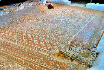
A walk across parkland from the museum takes you to the mosaic floor and
hypocaust, underground heating system, of an excavated villa. The hypocuast and
mosaic floor can be seen in a building in Verulaium Park and it brings to life
the scale of a major town house. It displays one of the first heating systems to
be installed and is believed to be 1800 years old. It was first uncovered in
1930. They are in their original location and are believed to have formed part
of the reception and meeting rooms of the large house which would have stood
here, probably part of a suite about double the size of what can be seen today.
The Hypcaust building is open during museum opening hours and has free entry.
|

 Hypocaust Mosaic
 |
Roman City Walls
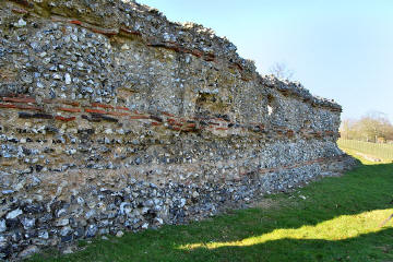
The Roman City walls originally around the town were constructed around AD
275, and 4 large gateways would have controlled the four main entrances into the
town. It was built from flint, brick, flint rubble and mortar and was over 10ft
thick at foundation level and 7ft thick higher up. In total the completed wall
covered two and a quarter miles. Today a short walk from the Verulamium Museum
you can see some remains of these walls which in fact is the core of the
original as well as the London Gate excavated foundations which are open to
view.

 Roman Wall - Verulamium Park
 |

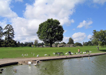
 Verulamium lake and
Roman wall remains
 |
|
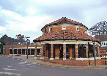
The Roman Museum
The Verulamium Park museum contains much information about the town, both
as a Roman and Iron Age settlement, plus Roman history in general. It is noted
for its large and colourful mosaics decorated with dolphins, lions, stags and
flower patterns, from the excavations, and intricate ceiling paintings in rich
brown and red pigments. It also has displays of many artefacts such as
pottery, tools and coins from the Roman town as well as coffins and other
remains unearthed in the surrounding area during 20th century building works. It
is considered one of the best museums of Roman history in the country using
recreated roman rooms, hands-on discovery areas, video presentations, and touch
screen databases, and its domed entrance has won an architectural award. Every
second weekend of the month Roman Soldiers can be found on site demonstrating
the tactics and equipment that would have been used by the Roman Imperial Army.
|

 Dave Skinner
 |
.
Planning Grid
|
Location: |
Verulium, St Albans,
Hertfordshire |
|
Grid Reference: |
TL136073 |
|
Getting there: |
On the western outskirts of St Albans just of
the A4147 in Verulamium Park |
|
Access: |
Roman Walls and Hypocaust are in the park with
a path leading to them from the car park |
|
Parking: |
|
|
Facilities: |
No refreshments in museum, cafe in park. |
|
Things To Do,
See and Photograph: |
|
|
What to take: |
|
|
Nature highlights: |
|
|
Address: |
Verulamium Museum
St Michael's Street
St Albans
Hertfordshire |
|
Postcode: |
AL3 4SW |
|
Telephone: |
01727 751810 |
|
Opening times: |
All year daily, except between Christmas and
new year.
Mon-Sat
10am-5.30pm and Sun 2pm-5.30pm |
|
Charges: |
Adults £3.30; Children,
Students and Seniors £2. Under 5's free.
Residents of St Albans and Friends of Museum - Free |
|
Photo Restrictions: |
|
|
Other Restrictions: |
|
|
Special Needs Access: |
Full wheelchair access to all areas of the
museum |
|
Special Needs Facilities: |
toilets |
|
Children Facilities: |
|
|
Dogs Allowed: |
|
|
CIN Page Ref: |
verulamium |
Date Updated: 07/2008 |
|

|
Please let us know any other information that we
can add to the Further information and Planning Grids or page and any errors that you discover. Before making a long trip to any location it is always
wise to double check the current information, websites like magazines may be
correct at the time the information is written, but things change and it is of
course impossible to double check all entries on a regular basis. If you have
any good photographs that you feel would improve the illustration of this page
then please let us have copies. In referring to this page it is helpful if you
quote the CIN Page Ref at the bottom of the Planning Grid above. To print the
planning grid select it then right click and print the selected area.
Please submit information on locations you discover so
that this system continues to grow.
|