Sark Lighthouse
Sark, Channel Islands
|

Location Guide |
Sark is the smallest of the Channel Islands
located east of Guernsey, and, although being Crown Property, is ruled by a Seigneur (feudal lord of manor). It is a
small island, only 3 miles long and 2 miles wide, the
north and south parts being almost separate islands joined only by a narrow
strip of land.
The lighthouse, at Point Robert, in the north
east of the island, was built by Trinity House in 1913. The light is elevated at
65 metres above sea level giving an indication of the steep rocky nature of the
coastline which makes landing on the island almost impossible, apart from at the
tiny stone harbour at Le Creux. The main function of the station is to guide
vessels, passing through the Channel Islands, away from the pinnacle of
Blanchard Rock, several miles to the east of Point Robert.
The white, octagonal tower of the lighthouse
rises from the flat roofed service rooms and dwellings, the whole complex clings
to the steep face of the cliff. The only means of access to the lighthouse is a
flight of steps down from the top of the cliff. The buildings, which are made of
stone are surrounded by a high retaining wall.
It was automated in 1994.
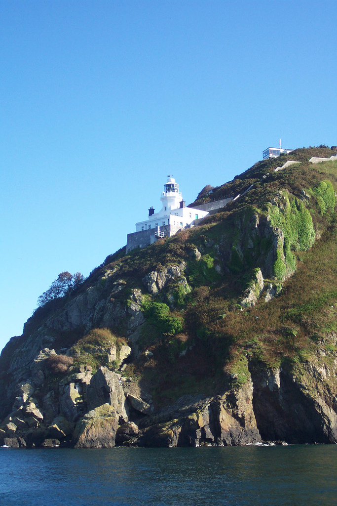
 Photo by
Paula Funnell Photo by
Paula Funnell

Access to the island of Sark is via passenger
ferry from St Peter Port on Guernsey and the only transportation on the island
is by foot, bicycle or horse-drawn carriage.
Lighthouse information Grid
|
Name: |
Sark Lighthouse,
Sark, Channel Islands |
|
Current status: |
Currently in use |
|
Geographic Position: |
49°
26'.26 N 02° 20'.67 W |
|
Grid Reference: |
|
|
Ceremonial County: |
Sark

|
|
Appearance: |
octagonal cylindrical tower rising from 2-story keeper's house; entire
structure painted white. |
|
Map
Link: |
|
|
Aerial photo: |
|
|
Other photos: |
view from above
|
|
Originally built: |
1913 |
|
Current lighthouse built: |
|
|
Height of Tower: |
16
Metres |
|
Height of light above mean sea level: |
65
Metres |
|
Character of light: |
One
White Flash Every 15 Seconds |
|
Character of fog signal: |
2 Blasts Every 30 Seconds |
|
Range of light: |
20
nautical miles |
|
Owned / run by: |
Trinity House
 |
|
Getting there: |
|
|
Access: |
Site open, tower closed. Located on a cliff and accessible by a staircase of
165 steps down from the cliff top. |
|
Website: |
|
|
Other Useful Websites: |
|
| Routes: |
|
|
Other Relevant pages: |
For more articles, lists and other information
see the
Lighthouses Section
Featured list of
Lighthouses - Channel
Islands
 |
|
Notes: |
|
|

|
Please let us know any other information that we
can add to the Grid or page and any errors that you discover. Before making a long trip to any location it is always
wise to double check the current information, websites like magazines may be
correct at the time the information is written, but things change and it is of
course impossible to double check all entries on a regular basis. If you have
any good photographs that you feel would improve the illustration of this page
then please let us have copies. In referring to this page it is helpful if you
quote both the Page Ref and Topic or Section references from the Grid below. To print the
planning grid select it then right click and print the selected area.
Please submit information on locations you discover so
that this system continues to grow.
|