|
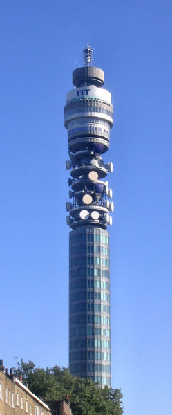
BT Tower
London
| Also known as the Post Office Tower.
175 metres (574ft) tall, with a further
section of aerial bringing the total height to 188 metres (617ft).
It replaced an earlier steel lattice tower and
was built to carry microwave transmitters, allowing telephone communication with
other parts of the UK. This links up with other towers and required line of
sight to work, so needed to be taller than other buildings. It is no longer open
to the public, last closed in 1981, the revolving restaurant at the top was
closed in 1980, the restaurant floor still occasionally rotates silently on its
nylon wheels, it takes 22 minutes to do one rotation. Occasional radio
broadcasts are made from the top of the tower and it has featured in many films
and dramas including Dr Who.
Although highly visible and had been for some
time open to the public, it was officially opened by Harold Wilson, the then
Prime Minsister, on 8th October 1965, and opened to the public at 3pm on 19th May
1966, by Tony Benn and Billy Butlin. It has appeared on many postcards and guides, until
the mid-1990s, but the building was officially a secret, and did not appear on
official maps.
The BT Tower was given Grade II listed
building status in 2003, several of the now defunct antennas located on the
building now cannot be removed, as they are protected by this listing.
Construction started in 1961.
Entry to the building is provided by two
high-speed lifts which travel at 6 metres per second, reaching the top of
the building in 30 seconds. Interestingly, an Act of Parliament was passed
to vary fire regulations, allowing the building to be evacuated by using the
lifts — it is the only building in the country where this is permitted.
|
  |
BT has over 200 radio masts and towers
throughout the UK, of these 12 are reinforced concrete and the rest steel
lattice structures. Seven of the twelve are known as Chilterns design, and are
identical except for their height, there are also 5 others of which the the
London BT Tower is one.
The other four are:-
- The British Telecom Tower, Birmingham
- Morborne Hill, Cambridgeshire
- Pur Down, Bristol
- Tolsford Hill, Folkestone, Kent
Links to more information on these and the 7
Chiltern towers can be found at
http://en.wikipedia.org/wiki/BT_Tower_%28disambiguation%29
Planning Grid
|
Location: |
BT Tower, London |
|
Grid Reference |
TQ291818 |
|
Map Link: |
Multimap
Google Maps aerial photograph |
|
Getting there: |
Underground, or road, see Multimap street plan |
|
Access: |
No access to building, can be seen from all
streets around |
|
Parking: |
A nightmare but some expensive car parks are
within walking distance. |
|
Facilities: |
None |
|
Things To Do,
See and Photograph: |
The tower, other attractions in area |
|
What to take: |
|
|
Nature highlights: |
|
|
Best Times to
Visit: |
Although usually photographed in the daytime
it can also be photographed at night when it is lit up. |
|
Address: |
60 Cleveland Street
London |
|
Postcode: |
W1H |
|
Telephone: |
|
|
E-mail: |
|
|
Website: |
http://en.wikipedia.org/wiki/BT_Tower |
|
Opening times: |
Not open |
|
Charges: |
Not open |
|
Photo Restrictions: |
None |
|
Other Restrictions: |
Can't enter it any longer |
|
Special Needs Access: |
none |
|
Special Needs Facilities: |
no |
|
Children Facilities: |
no |
|
Dogs Allowed: |
no |
|
Other useful
websites: |
http://www.lightstraw.co.uk/ate/main/postofficetower/
http://arts.guardian.co.uk/critic/feature/0,1169,641870,00.html |
|
CIN Page Ref: |
BT_Tower |
Date Updated: 03/08 |
Please let us know any other information that we
can add to this Planning Grid or page and any errors that you discover. Before making a long trip to any location it is always
wise to double check the current information, websites like magazines may be
correct at the time the information is written, but things change and it is of
course impossible to double check all entries on a regular basis. If you have
any good photographs that you feel would improve the illustration of this page
then please let us have copies. In referring to this page it is helpful if you
quote the CIN Page Ref at the bottom of the Planning Grid above. To print the
planning grid select it then right click and print the selected area.
Please submit information on locations you discover so
that this system continues to grow.
|