Cadbury Castle
South Cadbury, Somerset
Cadbury Castle is an ancient hill fort, near
South Cadbury, in Somerset. It has for centuries at least linked to King Arthur
as the location of Camelot, and has an old road sign showing this. This local
tradition, first written down by John Leland in 1532, stating that Cadbury
Castle was King Arthur's Camelot.
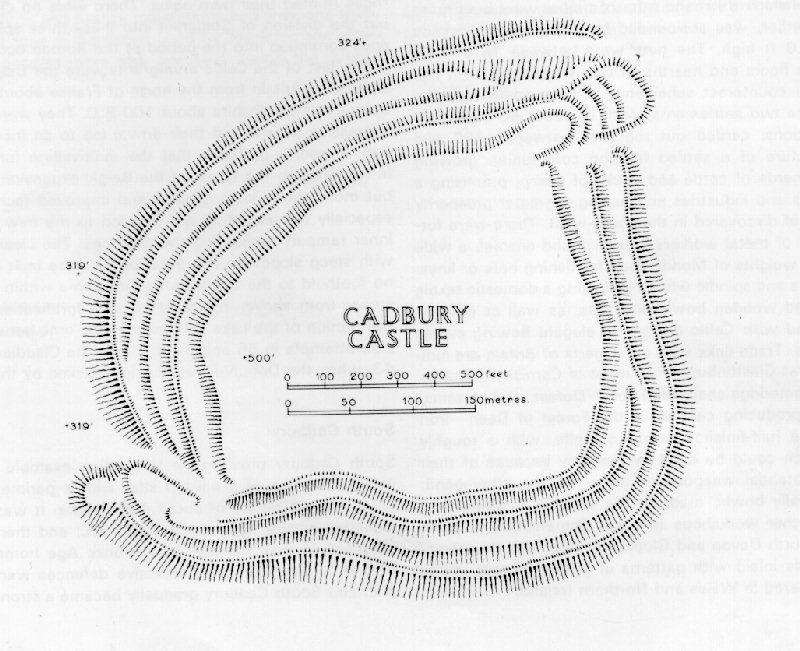
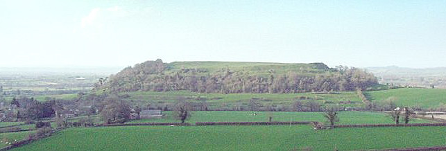
Today when you climb it, you see the impressive
multi bank earth works, that even today would be a challenge to create. It is
difficult without visiting to envisage the size of this place and once you do
just how it could have been constructed at the time it was. On the top is an
area large enough for a good sized village or small town. Besides the earth works
you can see the remains of an outer stone wall around the entire top, and
remains of some stone structures.


The views from the top are fantastic, you
can see Glastonbury Tor, 12 miles away, and the villages all lay out as if you
were in an aircraft looking down. You enter via a track from the road, and pass
through an original entrance. Its easy to see why people got the idea that this
was the remains of Camelot. However as you will come to discover this is only
the back door. The main entrance is at the opposite corner. There are a number of claims to be the location of
Camelot, and no one knows where it was or if it existed. See
places associated with King Arthur, and more
on him. There is also a second page linked to this that looks at the records
and other information in more detail.
What's in a name
Lot = piece of land, so Camelot is a piece of land by the
River Cam. The River
Cam runs past Cadbury Castle. Bury means fortification.
Often associated with towns that had town walls, so Camelot once fortified with
walls could become Cambury.
However some say the name 'Cadbury' has a SaxoBrythonic hybrid meaning 'Battle-Fort',
and that the prefix derives
from Cado, King of Dumnonia in the time of Arthur or thereabouts. Militarily the
location makes sense as a place where the south-western Brythons (perhaps from
the kingdom of Dumnonia) could have defended themselves against attacks from
lowland Brythons. Refortification could credibly have been a response to the
great Saxon raid of 473AD. If Arthur was indeed conceived at Tintagel, as
tradition asserts, as a prince of Dumnonia, Cadbury would have been close to his
eastern frontier. After his defeat it could have been renamed after Cado, that
was known at that time, perhaps he inherited Camelot.
There is also
- Villages of Queen Camel and West Camel
near to Cadbury Castle. (Local pronunciation was camal with the last A as
in father.)
- Villages of South Cadbury, grid ref SS910049 (near Cadbury
Castle) and North Cadbury grid ref ST635273 is
Somerset.
- Cadbury Castle, Devon Iron age hill fort
overlooking the Exe valley Bickleigh - Grid Reference SS913052
- Cadbury Camp, another Iron Age Hill Fort,
but smaller, 50 miles north near Tickenham, its well preserved and managed by
the National Trust. Grid reference ST 454724.
- Cadbury Hill also known as Cadbury-Congresbury
now, so as to avoid confusion. Iron Age Hill Fort in north Somerset near the
village of Cadbury at grid reference ST442649.
Excavations and other information we have on
Cadbury Castle.
They tell us that the hill fort was built
around 500BC, and was strengthened and extended at least 5 times. It has
large ramparts and had huge and elaborate timber defences.
Excavations have turned up material from the
Iron Age, and both Roman and Saxon items. Some of these items are in the
county museum at Taunton. The earliest material is from the Neolithic age.
Remains were found of rectangular house foundations, a blacksmiths and what is
thought to have been a temple. They found evidence that it was taken after a
major battle by the Romans about 50AD and then occupied by them. The defended
area at the top is 18 acres.
Julius Caesar described the larger Celtic Iron
Age settlements he encountered in Gaul as oppida and the term is now used
to describe the large pre-Roman towns that existed all across Western and
Central Europe. Many oppida grew from hill forts although by no means did all of
them have significant defensive functions. Oppida surrounded by earthworks are
known as enclosed oppida. The main features of the oppida are the architectural
construction of the walls and gates, the spacious layout and commanding view of
the surrounding area.. Caesar pointed out that each tribe of Gaul would have
several oppida but that they were not all of equal importance, perhaps implying
some form of hierarchy. In conquered lands, the Romans used the infrastructure
of the oppida to administer the empire and many became full Roman towns. This
often involved a change of location from the hilltop to lowlands nearby.
Following the withdrawal of the Roman
administration, the site is thought to have been in use from around 470AD until
some time after 580AD. Remains of a substantial 'Great Hall' (20 x 10 metres)
have been found, and evidence that the innermost Iron Age defences had
been refortified providing a defended site double the size of any other known
fort of the period. (Geoffrey of Monmouth set the year of Arthur's fall as 542).
On the central part the foundations of a
timber hall were discovered 63ft by 34ft, divided in two, with one part larger
than the others. A small building found close by may have been the kitchen. Only
the hall had been able to be dated to the time of Arthur. At the south-west
entry were the remains of a gatehouse of the same period. A cobbled road ten
feet wide climbed into the enclosure. It passed through double doors into a
nearly square wooden tower, and out through similar doors the other side, all
buried again after the excavations. Around the hill, on top of the earth
banks was a dry stone bank or wall 16 feet thick. Gaps where ancient timber had
rotted marked the places where massive posts had upheld a breastwork on the
outside, protecting men who stood on the wall. Beams had run across, binding the
structure together and supporting a platform, and perhaps, at intervals, wooden
watch towers. You can still see remains of the stonework. Although some other hill forts/castles were fortified a little in this period, no others
anything like what has been found at Cadbury Castle.
| Sherds of pottery from the eastern
Mediterranean were found from this period suggesting wide trade links. It
is thought it was the chief caer (castle or palace) of a major Brythonic ruler
and home to his royal family, his band of faithful followers, servants and
horses. Very similar items have been discovered at Tintagel suggesting a
connection. Between 1010 and 1020 the hill was reoccupied
for use as a temporary Saxon mint, briefly standing in for that at Bruton. |
 |
|
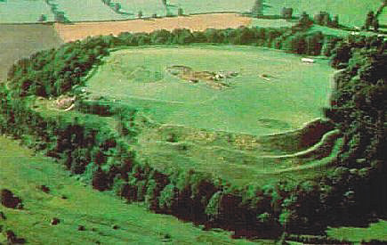 |
Today some of the sides are wooded but you can
still see the various levels of defensive ditches/banks, and walk around the
perimeter at the top, as well as across the central area. You will most likely
see a few other people, when visiting but so few that you can take photographs
of large areas of the castle without people getting into your photographs. Entry
is free, and a free car park is provided. A notice board in the car park gives a
brief history. |
There are quite a lot of hill forts or castles,
many are impressive, but few match Cadbury Castle and the added intrigue or
stories about it being King Arthur's Camelot has got to make it worth visiting.
Planning Grid
|
Location: |
Cadbury Castle, South Cadbury,
Somerset |
|
Grid Reference |
ST 628251 |
|
Map Link: |
Multimap
Google Maps Aerial photograph |
|
Getting there: |
5 miles south west of
Yeovil. Take the A305 east from Sparkford, turn to
South Cadbury, go through village and towards Sutton Montis, and car park is
on your right. |
|
Access: |
Go from car park back towards South Cadbury,
lane on your left is now clearly marked. This takes you up through a gate
directly to the castle top. A Tip - pace yourself, don't take it to fast and
you will get to the top. |
|
Parking: |
Parking area provided by road.
Free |
|
Facilities: |
None |
|
Things To Do,
See and Photograph: |
Large ancient hill
fort, views. |
|
What to take: |
Tripod and other items if you want to take a
panorama view, the area is not very muddy, but footwear suitable for walking
across fields is recommended. It can be quite windy on the top so take a coat
with you. |
|
Nature highlights: |
You are likely to see quite a bit of wildlife,
as well as other activity over a large area. You will often see extensive
displays of seasonal wild flowers. |
|
Best Times to
Visit: |
Any time. |
|
Address: |
|
|
Postcode: |
|
|
Telephone: |
|
|
E-mail: |
|
|
Website: |
http://www.earlybritishkingdoms.com/archaeology/cadbury.html |
|
Opening times: |
Open all the time |
|
Charges: |
Free entry |
|
Photo Restrictions: |
None |
|
Other Restrictions: |
None |
|
Special Needs Access: |
Steep climb, not suitable for those unable to walk well. |
|
Special Needs Facilities: |
None |
|
Children Facilities: |
Ideal safe place for children. The banks are
high and steep so keep small children away from the edge. |
|
Dogs Allowed: |
No known restrictions but suggest they are kept on a lead |
|
Other useful
websites: |
http://www.britannia.com/history/arthur/cadcast.html
http://en.wikipedia.org/wiki/Cadbury_Castle
http://en.wikipedia.org/wiki/Geoffrey_Ashe |
|
CIN Page Ref: |
cadbury_castle |
Date Updated: 03/08 |
Please let us know any other information that we
can add to this Planning Grid or page and any errors that you discover. Before making a long trip to any location it is always
wise to double check the current information, websites like magazines may be
correct at the time the information is written, but things change and it is of
course impossible to double check all entries on a regular basis. If you have
any good photographs that you feel would improve the illustration of this page
then please let us have copies. In referring to this page it is helpful if you
quote the CIN Page Ref at the bottom of the Planning Grid above. To print the
planning grid select it then right click and print the selected area.
Please submit information on locations you discover so
that this system continues to grow.
|