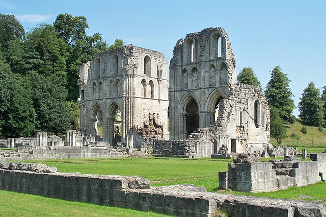
Roche Abbey
nr Maltby, Yorkshire
|

Quick Guide
See below grid for details |

Roche Abbey
 Jeff Pearson

Built by Cistercian Monks in 1147 and dissolved
in 1538. Today the ruins are in the care of English Heritage.
Set in a valley landscaped by 'Capability'
Brown in the 18th century, its most striking feature is the eastern end of its
church, which was built in the Gothic style of around 1170. The story of the
pillaging of Roche, recorded by the son of an eyewitness, is among the most
vivid documents of the Dissolution of the Monasteries, and details what the
local community did with its possessions, as well as details of its destruction
and valuable artefacts, timber, lead and stone were removed and it was left as a
ruin.
Its ownership passed through many hands until
it was acquired by the 4th Earl of Scarborough who decided it needed
revitalising and adjoining to his seat and Sandbeck Park. However he enlisted
the help of Capability Brown who demolished buildings, built large earth mounds
and turfed the whole site, for it to no longer be seen. Until that is the late
19th century and subsequent excavations in the 1920's when it was uncovered to
what you see today.
It has one of the most complete ground plans of
any English Cistercian monastery, laid out as excavated foundations, and this
can be best seen from the cliff path walk which provides access to a view across
the abbey grounds where its layout can be appreciated. What is left for you to
view and photograph today is the low-standing outline walls and the walls of the
church still standing to full height displaying the gothic French idealism of
its design and architecture. Later additions to the buildings included a kitchen
area and abbot's quarters, that were built on the other side of the beck. These
quarters were accessed by a bridge which still stands. The monks had latrines
which were over Maltby Beck so the running water took away the waste. They
dammed the stream higher up to ensure fast flowing water, quite a modern
facility for the 13th century. As well of course as the Abbey House.
|
Location: Roche Abbey, Maltby, Rotherham,
Yorkshire |
|
Grid Reference: SK542900 |
Ceremonial County:
Yorkshire
 |
|
Map Link:
StreetMap

|
Aerial photo:
Google Aerial Photo

|
|
Getting there: 1.5 miles south of Maltby off
the A634 |
|
Access: Access to abbey and grounds: access to
main part of ruins over smooth grass and to south side of stream via grass
slope. Parking 250m from admissions on a rough path. |
Website:
EH
 |
Other Useful Websites:
Wiki
 PEH
PEH
 |
|
Email: |
|
Address: Maltby, Rotherham, Yorkshire |
|
Postcode: S66 8NW |
Telephone: 01709 812739 |
|
Opening Times: 1 Apr-30 Sep 11am-4pm Thurs-Sun |
|
Charges: Adult: £3.30; Child £2; Concession
£3; English Heritage Members: Free |
|
Nearby Locations: |
Other Location Pages:
Abbey Section
 |
|
Notes: Facilities include: Toilets: In
Abbey House adapted with level access. Seats. Shop, refreshments, picnic
areas
|
|

|
This page is a Quick Guide, the idea of Quick
Guides is to allow very basic information and linking forward information to be
added to the system rather than having to wait until a full location guide has
been developed. It should therefore be considered a development stage rather
than a finished objective. Once more information is known the objective is to
create either a Location or Featured Location page which has two grids and far
more information.
Please let us know any other information that we
can add to the Grid(s) or page and any errors that you discover. Before making a long trip to any location it is always
wise to double check the current information, websites like magazines may be
correct at the time the information is written, but things change and it is of
course impossible to double check all entries on a regular basis. If you have
any good photographs that you feel would improve the illustration of this page
then please let us have copies. In referring to this page it is helpful if you
quote both the Page Ref and Topic or Section references from the Grid below. To print the
planning grid select it then right click and print the selected area.
Please submit information on locations you discover so
that this system continues to grow.
|