Hulne Priory
Alnwick, Northumberland
|

Quick Guide |
Hulne Priory was a Carmelite friary founded in
1240 and possibly the first one established in England. At the time of the
Dissolution the church was dissolved in 1538 but parts of the building remain.
These include a tower and precinct wall, given to the abbey in 1488 to defend
the church, and main claustral buildings. Lesser buildings survive only as
foundations. Excavations at the end of the 19th century exposed the ground plan
of the abbey and part of an Anglo-Saxon cross shaft was found.
The chapel has been transformed into a modern
residence, and another house has been built east of the cloister. The tower
stands at full height, having been remodelled in the late 18th century. The
interior was partially Gothicised during these works, but the vaulted basement
ceiling is original. Unique to Hulne is the Carmelite infirmary, which is built
on the standard hospital plan of the medieval period.
 Click on images to see larger
versions


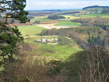
Photo
taken from Brizlee Tower in Hulne Park
 Les Hull

How to Get to the
Priory
The Priory is situated on a hill which
overlooks the River Aln in a very tranquil location deep inside Hulne Park,
which is part of the estate of Alnwick Castle and the public are granted
access to walk on some of the tracks and roads.
From Ratten Row pass
through the Forest Lodge gateway into the park. Follow the road ignoring
deviations left and right. At the Park Farm road junction bear left. Further
along the road. Hulne Priory is seen to the right, in the middle distance.
The road now drops down to East Brizlee Farm and past it to cross the Aln at
east Brizlee bridge. Take a right at the bridge and make your way along
beside the river to the Iron Bridge. The Priory is now up to your left at
the top of the hill.
You can cross
the grass and climb the hill to the Priory. To use the path to the priory,
follow the river round to a gate and go left uphill and then left again to
enter the Priory grounds.
|
Location: Hulne Priory, Hulne Park, Alnwick,
Northumberland |
|
Grid Reference:
NU163157 |
Ceremonial County:
Northumberland
 |
|
Map Link:
StreetMap

|
Aerial photo:
Google Aerial
 |
|
Getting there: In Alnwick the road to Hulne
Park is called Ratten Row and is accessed from the B6346 Wooler Road. |
|
Access: No car park or vehicle access - There
is access to the priory grounds on foot only, but there is a private house
in the grounds. From Ratten Row pass through the Forest
Lodge gateway into the park. Follow the road ignoring deviations left and
right. At the Park Farm road junction bear left. Further along the road.
Hulne Priory is seen to the right, in the middle distance. The road now
drops down to East Brizlee Farm and past it to cross the Aln at east Brizlee
bridge. Take a right at the bridge and make your way along beside the river
to the Iron Bridge. The Priory is now up to your left at the top of the
hill.
You can cross the grass and climb the hill to the Priory. To
use the path to the priory, follow the river round to a gate and go left
uphill and then left again to enter the Priory grounds. |
|
Website: |
Other Useful Websites:
Wiki
 PEH
PEH
 More Pics
 |
|
Email: |
|
Address: |
|
Postcode: NE66 2LL |
Telephone: |
|
Opening Times: Any reasonable time, but be
respectful of those living nearby. |
|
Charges: None |
|
Nearby Locations: |
Other Location Pages:
Abbey Section
 |
|
Notes: You can park in Ratten Row, or there is
a large car park off Greenwell Road in Alnwick.
|
|

|
This page is a Quick Guide, the idea of Quick
Guides is to allow very basic information and linking forward information to be
added to the system rather than having to wait until a full location guide has
been developed. It should therefore be considered a development stage rather
than a finished objective. Once more information is known the objective is to
create either a Location or Featured Location page which has two grids and far
more information.
Please let us know any other information that we
can add to the Grid(s) or page and any errors that you discover. Before making a long trip to any location it is always
wise to double check the current information, websites like magazines may be
correct at the time the information is written, but things change and it is of
course impossible to double check all entries on a regular basis. If you have
any good photographs that you feel would improve the illustration of this page
then please let us have copies. In referring to this page it is helpful if you
quote both the Page Ref and Topic or Section references from the Grid below. To print the
planning grid select it then right click and print the selected area.
Please submit information on locations you discover so
that this system continues to grow.
|